
INSIGHTS
AI Vision Training: Optimizing with High-Quality Drone Footage
The efficacy of autonomous infrastructure inspection is entirely dependent on the engineering precision of the underlying data rather than the complexity of the neural network itself. Relying on inconsistent, manual flight patterns often results in a data deficit where high-resolution imagery lacks the spatial context required for sophisticated feature extraction. You've likely encountered the fiscal and operational strain of manual image labeling and the lack of repeatable datasets for critical engineering decisions.
Optimizing AI Vision Training with Drone Video Footage requires a transition from qualitative observation to a quantitative, evidence-based data pipeline.
This article provides a technical framework for mastering the conversion of raw aerial captures into engineering-ready models for autonomous infrastructure oversight. We'll explore the integration of high-fidelity data acquisition with scalable labeling workflows to reduce risk and enhance asset lifecycle management. By the conclusion, you'll understand the methodology for establishing a repeatable intelligence ecosystem that transforms visual data into actionable industrial insights.
Key Takeaways
Define the technical parameters for high-fidelity drone datasets to facilitate the transition from qualitative raw video to quantitative engineering intelligence.
Implement advanced data annotation and feature extraction protocols to isolate critical infrastructure anomalies such as corrosion patterns and structural deformations.
Optimize AI Vision Training with Drone Video Footage through a systematic "data-to-decision" pipeline designed for repeatable and evidence-based engineering outcomes.
Leverage integrated platform capabilities to scale autonomous inspection workflows across the entire asset lifecycle, ensuring long-term compliance and reduced operational risk.
The Architecture of AI Vision Training: High-Fidelity Drone Datasets
AI vision training is the systematic process of instructing neural networks to identify and categorize infrastructure anomalies within aerial datasets. While standard consumer drones capture high-definition video, engineering-grade intelligence requires a shift toward curated, high-fidelity datasets. Raw drone video often lacks the semantic structure necessary for precise Computer vision applications. For critical infrastructure, "accurate" data is defined by the ability to detect hairline fractures as small as 1/8 inch from a distance of 30 feet, a benchmark that demands rigorous data acquisition standards. Effective AI Vision Training with Drone Video Footage relies on this foundational precision to ensure model reliability across diverse asset classes.
Sensor Fusion: Beyond Standard Video
Robust AI models require more than two-dimensional visual inputs. Integrating LiDAR point clouds with video frames provides the essential spatial context that allows a model to understand depth and scale. This fusion enables the identification of volumetric changes or structural shifts that video alone might obscure. Incorporating thermal IR data is vital for utility and pipeline inspections; it allows neural networks to correlate visual anomalies with heat signatures, identifying subsurface leaks or electrical hotspots invisible to electro-optical sensors. This multi-modal approach is central to the DroneWorksIQ methodology for generating repeatable engineering intelligence.
Real-World vs. Simulated Environments
Synthetic data offers a controlled environment for initial testing, yet it frequently fails to account for the chaotic variables found at industrial sites. Real-world data is indispensable for training models to handle complex lighting, occlusion, and varying atmospheric conditions. High-stakes engineering applications require datasets derived from actual asset environments to ensure the AI can distinguish between a critical structural deformation and a benign surface shadow. Relying solely on simulated environments introduces significant risk when deploying autonomous inspection systems in the field. Authentic AI Vision Training with Drone Video Footage provides the evidence-based grounding necessary for strategic industrial application and long-term asset lifecycle management.
Data Annotation and Feature Extraction for Infrastructure Intelligence
Manual annotation processes present a significant bottleneck in the deployment of autonomous systems. Transitioning to AI-assisted feature extraction allows for the rapid identification of critical anomalies across extensive asset networks. Effective AI Vision Training with Drone Video Footage focuses on the isolation of corrosion patterns, structural deformation, and vegetation encroachment with surgical precision. The automation of these workflows reduces the fiscal burden of manual feature extraction while increasing the granularity of data captured during routine flights. This methodology aligns with the streamlined bridge inspection framework; it leverages computer vision to automate defect measurement and localization. By shifting toward an evidence-based decision-making model, engineering teams secure the repeatable data required for rigorous compliance and long-term structural integrity oversight.
Defining Engineering-Grade Labels
Standardization of annotation protocols is mandatory for industrial documentation. Labels for infrastructure components, such as facade expansion joints or pipeline welds, must adhere to strict regulatory standards to ensure data interoperability. This level of precision ensures that every identified feature serves as a verifiable data point within the asset's digital record. Maintaining consistency in labeling across successive inspection cycles is the only way to track degradation rates accurately over time. This repeatable intelligence loop is essential for maintaining the high-stakes data environments required by corporate decision-makers who prioritize methodical accuracy.
AI-Driven Geospatial Analytics
The transformation of two-dimensional video frames into three-dimensional geospatial insights represents the next evolution in infrastructure intelligence. Through the integration of photogrammetry and machine learning, AI-driven geospatial analytics provides a comprehensive spatial understanding that standard visual records lack. This process enhances the depth of training datasets by correlating visual defects with precise coordinate data. Implementing these advanced analytical workflows through specialized Utility and Pipeline Inspection Services ensures that every frame of video contributes to a robust, engineering-ready intelligence model.
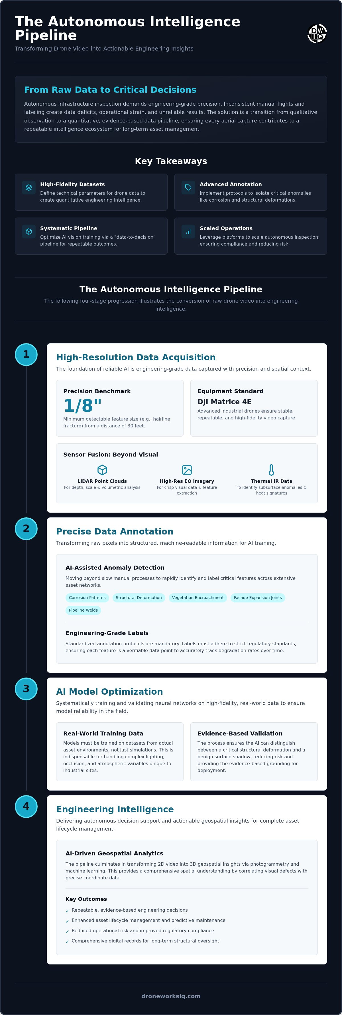
Engineering-Grade Training: A Strategic Framework for Autonomous Inspection
Enterprise-scale deployment of autonomous inspection systems necessitates a transition from ad-hoc data capture to a rigorous "data-to-decision" pipeline. This systematic framework ensures that every phase of the intelligence cycle increases confidence in engineering outcomes. Capturing minute structural components, such as a 1/2-inch bolt on a utility tower, requires specific hardware configurations capable of 4K video at 60fps. This high-resolution throughput provides the pixel density essential for precise classification during AI Vision Training with Drone Video Footage. The optimization of AI Vision Training with Drone Video Footage through edge computing further facilitates real-time navigation and feature identification within complex industrial environments.
The 5-Step Autonomous Training Workflow
Precision Data Collection: Deployment of specialized hardware for synchronized high-resolution EO, IR, and LiDAR capture to establish a multi-modal baseline.
Data Pre-processing: Normalization of video frames and alignment of geospatial metadata to ensure training consistency across diverse asset classes.
Expert Annotation: Application of technical, clinical labeling to structural features, ensuring that the AI recognizes specific engineering ground truths.
Model Training and Validation: Iterative testing against established damage classes, aligning with methodologies like those found in Vision-Based Detection of Bridge Damage.
Deployment and Monitoring: Integration of the validated AI model into a comprehensive infrastructure digital twin for long-term asset oversight.
Validation and Compliance Protocols
Technical validation protocols must prioritize the total elimination of false negatives in critical defect detection, such as structural cracks or gas leaks. Automated intelligence reports must satisfy the documentation standards required for enterprise asset management and regulatory compliance. This level of analytical scrutiny ensures that the resulting data is actionable and defensible within a strategic industrial context. Organizations seeking to implement these rigorous standards should utilize professional Drone Mapping and Photogrammetry Services to secure a verifiable data foundation.
The DroneWorksIQ Advantage: Scaling AI Vision for Asset Lifecycles
The DroneWorksIQ Platform functions as the primary conduit for converting unstructured aerial captures into actionable engineering intelligence. By providing a unified environment for AI Vision Training with Drone Video Footage, the platform facilitates a transition from manual data silos to integrated asset lifecycle management. This strategic approach ensures that infrastructure inspection workflows become fully autonomous; it links real-time data acquisition directly to predictive maintenance models. DroneWorksIQ positions itself as a strategic partner for organizations prioritizing evidence-based insights over traditional, qualitative observation methods.
Repeatable Intelligence for Enterprise Assets
Operational risk reduction in national infrastructure projects depends on the availability of accurate, repeatable, and evidence-based data. The platform standardizes data ingestion protocols to ensure consistency across disparate geographic locations and asset types. This uniformity is critical for enterprise-level decision-makers who require a single source of truth for engineering compliance. By establishing a rigorous baseline for AI Vision Training with Drone Video Footage, organizations can achieve a level of precision that manual flights cannot replicate. This methodical accuracy supports high-stakes industrial applications where data integrity is non-negotiable.
Integrating AI into the Asset Lifecycle
Scaling AI vision requires moving beyond the limitations of periodic inspections toward continuous, data-driven health monitoring. Integrating construction intel drone survey data into the lifecycle management process provides a longitudinal dataset for long-term AI training. This integration allows for the detection of subtle degradation patterns over months or years, transforming how assets are managed from planning through decommissioning. DroneWorksIQ serves as the strategic partner for entities seeking to leverage this comprehensive oversight. For organizations requiring specialized Digital Twinning Services, the platform offers the necessary analytical depth to maintain competitive advantage in complex high-stakes environments.
Advancing Autonomous Infrastructure Oversight
The transition from manual data collection to autonomous infrastructure intelligence requires a fundamental shift in how visual data is perceived and processed. Engineering-grade outcomes depend on high-fidelity datasets that integrate LiDAR and high-resolution video to provide the necessary spatial context for complex feature extraction. By implementing a systematic training framework, organizations can eliminate the inconsistencies inherent in manual flights. Effective AI Vision Training with Drone Video Footage establishes the foundation for repeatable, evidence-based decision-making across extensive asset networks. This methodology ensures that data remains actionable and compliant throughout the entire asset lifecycle.
DroneWorksIQ provides the comprehensive platform necessary to bridge the gap between raw aerial capture and sophisticated engineering models. Our focus on accurate, repeatable data and expert AI-driven geospatial analytics ensures that your intelligence pipeline remains scalable and reliable. Secure the technical foundation required for long-term asset lifecycle management and reduce operational risk through professional precision. Transform your aerial data into engineering intelligence with DroneWorksIQ and lead the shift toward fully autonomous infrastructure intelligence. Your path to sophisticated, data-driven oversight begins with high-fidelity engineering ground truth.
Frequently Asked Questions
How much drone video footage is required to train a reliable AI vision model?
The volume of data required depends on the complexity of the asset features and the desired model confidence levels. While initial testing may utilize several hundred high-fidelity frames, enterprise-grade reliability typically necessitates thousands of diverse samples. AI Vision Training with Drone Video Footage requires datasets that capture various lighting conditions and asset orientations to ensure the neural network can generalize accurately across different industrial environments.
Can AI vision detect structural defects as small as 1/4 inch from a drone?
AI vision systems can identify structural defects as small as 1/4 inch when the data acquisition process is optimized for high resolution and specific standoff distances. Achieving this precision requires the use of 4K or higher resolution sensors and meticulous flight planning to maintain consistent pixel density. This technical capability is essential for detecting early-stage corrosion or hairline fractures that might compromise infrastructure integrity if left unaddressed.
What is the difference between standard data labeling and engineering-grade annotation?
Standard data labeling focuses on general object identification, whereas engineering-grade annotation applies technical ground truth to specific industrial features. This clinical approach involves classifying anomalies according to established engineering standards, such as specific pipeline weld types or concrete spalling patterns. Precise annotation ensures that the resulting intelligence is actionable for structural engineers and compliant with the documentation requirements for long-term asset lifecycle management.
How does LiDAR data improve the accuracy of AI vision models for infrastructure?
LiDAR data provides the spatial context and depth perception that two-dimensional video frames lack. By integrating point clouds with visual imagery, AI Vision Training with Drone Video Footage gains a comprehensive three-dimensional understanding of asset geometry. This sensor fusion allows the model to distinguish between benign surface shadows and actual structural deformations, significantly reducing false negatives and enhancing the reliability of autonomous feature extraction.
Is autonomous drone inspection compliant with national engineering standards?
Autonomous drone inspection is compliant with national standards when the data pipeline is evidence-based and produces repeatable, high-fidelity records. Compliance depends on the ability to generate automated reports that meet the rigorous documentation requirements of asset management agencies. Utilizing an integrated platform ensures that every inspection cycle follows a standardized workflow, providing the defensible data necessary for long-term infrastructure oversight and regulatory adherence.
Originally published by DroneWorksIQ. Legacy source.