
INSIGHTS
Drone Forestry Applications
Relying on manual plot sampling to value thousands of acres of timberland is an invitation for catastrophic financial forecasting error. Enterprise foresters recognize that ground-based surveys are structurally limited by high operational costs, safety risks, and the statistical volatility of extrapolating sparse data sets across complex terrains. Utilizing Drones Forestry Applications Forecasting Yields and Growth Rates facilitates the transformation of raw aerial imaging into precise engineering intelligence. This shift replaces traditional estimation with a methodical, data-driven approach to timber volume and health assessment.
You'll discover how enterprise-grade LiDAR and AI-driven analytics transform raw aerial data into accurate forest yield forecasts and growth rate projections. This article provides a repeatable framework for forest inventory and the deployment of predictive models for yield and carbon sequestration. We examine the integration of high-density point clouds into existing asset management workflows to deliver evidence-based data for comprehensive lifecycle management. The transition from manual sampling to digital twinning ensures that asset lifecycle decisions are rooted in high-fidelity geospatial reality.
Key Takeaways
Precision Forestry: The Transition from Manual Sampling to Aerial Intelligence
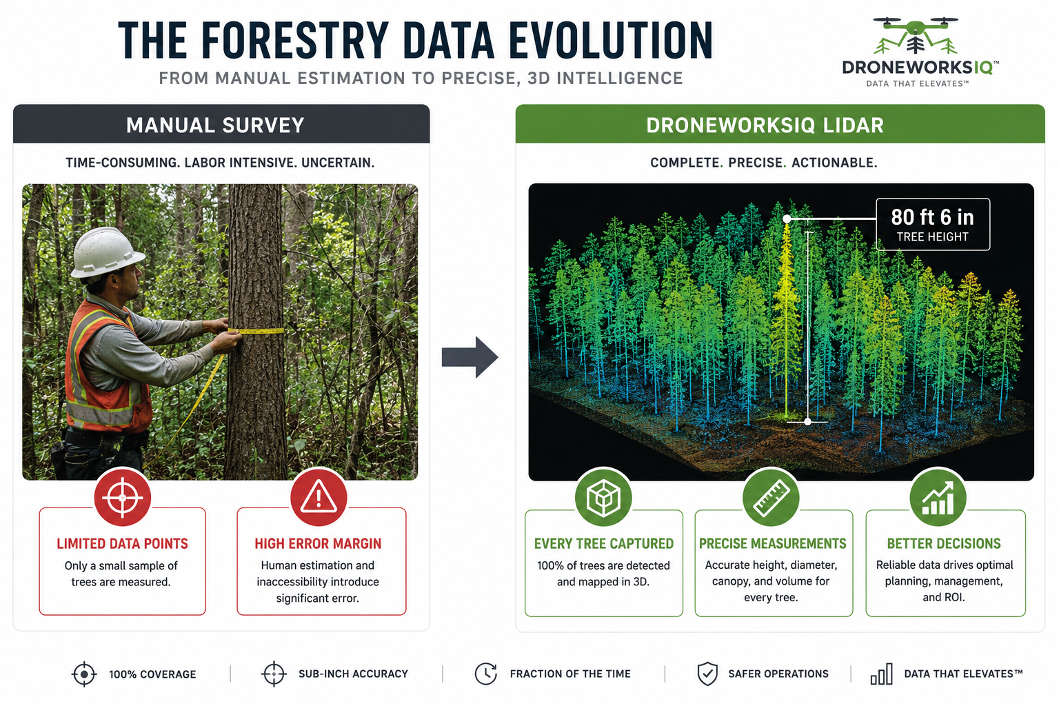
Precision forestry is the systematic application of high-resolution geospatial data to manage timber assets at the individual stem level. Traditional Forest management relied on manual plot sampling; this process required foresters to extrapolate data from a fraction of the land to estimate the whole. This method is structurally susceptible to sampling bias and human error. It often results in significant timber volume discrepancies that jeopardize financial forecasts. Digital twinning allows for a level of granular oversight previously impossible with ground-based methods.
Deploying Drones Forestry Applications Forecasting Yields and Growth Rates eliminates these statistical gaps by providing 100% area coverage. Rather than estimating based on small circles of trees, enterprise-grade UAVs capture comprehensive datasets that account for every individual asset within a stand. This engineering intelligence approach converts raw aerial pixels into evidence-based metrics for compliance and financial reporting. The output is a high-fidelity digital record that serves as a single source of truth for forest inventory.
Key Takeaway: Aerial intelligence reduces survey time by 70% while increasing data density by orders of magnitude.
Addressing the Scale Challenge
National-scale timber assets present logistical hurdles that ground crews cannot overcome. Dense undergrowth and steep topography frequently render ground-based measurements inaccurate or physically impossible. Ground crews simply cannot maintain the pace required for modern industrial standards. Autonomous aerial data collection provides the only viable solution for managing expansive holdings. Implementing Drones Forestry Applications Forecasting Yields and Growth Rates allows operators to bypass topographical obstacles, maintaining consistent data quality across thousands of acres. This scalability provides the foundation for reliable asset lifecycle management.
LiDAR and Multispectral Sensors: The Mechanics of Forest Quantification
The adoption of Drones Forestry Applications Forecasting Yields and Growth Rates relies on the precise deployment of active remote sensing technologies. LiDAR operates as the primary instrument for quantifying forest structure beneath the canopy. Unlike passive photogrammetry, LiDAR pulses penetrate gaps in foliage to provide an accurate Digital Terrain Model (DTM). This capability is fundamental to US Forest Service drone applications, where terrain mapping and fire fuel assessment require high-fidelity ground data. By mapping the forest floor through dense leaves, enterprise operators establish a reliable baseline for all subsequent volumetric calculations.
Multispectral imaging complements structural data by assessing chlorophyll absorption via the Normalized Difference Vegetation Index (NDVI). This identifies species-specific vigor and early-stage physiological stress. Maintaining identical flight paths across multi-temporal surveys ensures year-over-year growth accuracy. When these sensor feeds are integrated into AI-driven geospatial analytics, the resulting models provide a comprehensive view of ecosystem health. This rigorous sensor fusion is essential for Drones Forestry Applications Forecasting Yields and Growth Rates because it links biological vitality to structural biomass.
Quantifying Structural Metrics in Imperial Units
Structural analysis requires precise vertical measurements. Tree height is recorded in feet and inches, allowing foresters to track growth increments as specific as 12 in per year. Crown Base Height (CBH) is a critical metric for modeling vertical fire spread and merchantable timber volume. These metrics facilitate precise yield modeling, ensuring that financial projections reflect actual biological growth rather than statistical approximations.
The Digital Twin of the Forest
The synthesis of LiDAR and multispectral data creates an infrastructure digital twin of the timber asset. This 3D representation enables virtual harvest planning and the strategic routing of logging infrastructure. It's a sophisticated tool for simulating operational impacts before ground crews are deployed. For organizations seeking to optimize these workflows, professional LiDAR Data Collection and Analysis services provide the necessary high-density point clouds for enterprise-grade modeling.
Forecasting Yields and Growth Rates: The Predictive Modeling Workflow
Predictive modeling begins with a foundational baseline. High-density LiDAR pulses generate a three-dimensional point cloud to establish current biomass and volume, quantified in cubic feet. Once the baseline is set, the workflow transitions to individual stem isolation. This granular approach is the core of Drones Forestry Applications Forecasting Yields and Growth Rates. By applying temporal analysis, operators compare current datasets against multi-year historical scans to calculate the Mean Annual Increment (MAI). This longitudinal data informs site-specific growth curves, allowing for the projection of future timber volume and expected financial yields with engineering-grade accuracy.
The systematic comparison of temporal datasets identifies deviations in growth patterns that ground-based sampling often misses. These variations might indicate localized nutrient deficiencies or early-stage pest infestations. By isolating these factors, foresters can adjust management plans in real-time to preserve asset value. The transition from raw data to actionable forecasting requires a structured pipeline where every data point is verified against the digital twin.
AI-Driven Feature Extraction for Accuracy
Machine learning algorithms process raw point clouds to identify species based on crown geometry and spectral signatures. This automation converts disorganized spatial data into engineering intelligence. It enables precise harvest scheduling by identifying which stands have reached optimal maturity. This methodical approach eliminates the guesswork inherent in manual plot assessments, providing a clear roadmap for timber extraction and replanting cycles. Every tree is treated as a distinct data point within the broader asset management framework.
From Biomass to Carbon Credits
Accurate volume forecasting in cubic feet is mandatory for participation in carbon sequestration markets. These markets require rigorous, evidence-based documentation for compliance and third-party auditing. Utilizing aerial intelligence provides the necessary data density to verify sequestration rates over time. This ensures that carbon offsets are rooted in physical reality rather than theoretical estimates. For enterprises requiring these high-fidelity insights, DroneWorksIQ provides LiDAR Data Collection and Analysis to support data-driven asset management and environmental compliance.
Implementation: Integrating Drone Intelligence into Asset Management
The DroneWorksIQ Platform serves as the definitive architecture for managing the full geospatial data lifecycle. Engineering-grade aerial intelligence requires seamless integration with existing GIS and ERP systems to facilitate sophisticated timber management. This interoperability ensures that granular insights derived from Drones Forestry Applications Forecasting Yields and Growth Rates are immediately accessible for strategic asset planning. It's no longer sufficient to collect data; that data must actively inform the enterprise resource planning environment to drive operational efficiency.
Long-term asset lifecycle management relies on the repeatability of high-resolution datasets. Tracking growth increments as minor as 6 in requires standardized flight protocols and sensor calibration across multiple years. Deploying enterprise drone mapping services allows national-scale firms to maintain this consistency across vast topographical variations. This methodical approach ensures that yield projections are based on a stable, empirical framework rather than fragmented ground-based observations.
Strategic Geospatial Consulting
Data acquisition is merely the initial phase; professional interpretation is what converts raw point clouds into strategic assets. DroneWorksIQ acts as a specialized consultant for national-scale infrastructure and forestry firms, providing the analytical oversight necessary to navigate complex datasets. This partnership ensures that the nuances of species-specific growth and terrain variability are accurately reflected in financial models. Strategic consulting bridges the gap between technical sensor output and executive-level intelligence.
Ensuring Compliance and Reliability
Stakeholders and investors demand evidence-based reporting that can withstand rigorous auditing. Automated data pipelines provide a transparent record of forest health and volume, replacing subjective manual estimates with verifiable metrics. This level of reliability is essential for maintaining trust in environmental and financial disclosures. For organizations ready to modernize their operations, you can Transform your forestry data into engineering intelligence with DroneWorksIQ.
Modernizing Timber Valuation Through Geospatial Intelligence
The transition from statistical estimation to engineering-grade reality represents the critical evolution of modern forest management. By replacing manual plot sampling with 100% aerial coverage, enterprises eliminate the financial volatility associated with sparse data sets. High-density LiDAR point clouds and multispectral health assessments provide the granular foundation required for Drones Forestry Applications Forecasting Yields and Growth Rates. These technologies enable the creation of repeatable digital twins that serve as a single source of truth for timber volume and carbon sequestration metrics.
Strategic integration of this data into existing ERP and GIS workflows ensures that geospatial insights are translated into actionable asset lifecycle decisions. DroneWorksIQ provides engineering-focused data for asset-intensive sectors; we utilize AI-driven analytics to deliver repeatable results across national service territories. Moving beyond raw imagery to predictive intelligence allows foresters to optimize harvest schedules and verify compliance with absolute precision. It's a fundamental shift that empowers corporate decision-makers to handle complex data environments with methodical accuracy.
Request a Consultation for LiDAR Forestry Analysis
Establishing a high-fidelity data framework today secures the long-term resilience and valuation of your timber assets.
Frequently Asked Questions
How accurate are drone-based forest yield forecasts compared to manual sampling?
Drone-based forecasts provide superior accuracy by eliminating the statistical bias inherent in manual plot extrapolation. While traditional ground surveys rely on sparse data points, UAVs deliver 100% area coverage across the entire timber asset. Utilizing Drones Forestry Applications Forecasting Yields and Growth Rates ensures that volume estimates are derived from total biomass measurements rather than small, potentially unrepresentative samples. This comprehensive data capture significantly reduces the margin of error in financial forecasting.
Can LiDAR penetrate dense canopy to measure tree height in feet and inches accurately?
LiDAR pulses effectively penetrate gaps in dense vegetation to establish a precise Digital Terrain Model (DTM). This allows for the calculation of tree height in feet and inches by measuring the vertical distance between the highest point of the canopy and the ground return. Sensors provide high-fidelity structural metrics that are far more reliable than visual estimations. These exact vertical profiles are essential for identifying merchantable timber volume and assessing vertical fire fuel ladders.
What is the typical ROI for implementing drone-based growth rate monitoring?
The return on investment is primarily driven by a 70% reduction in survey time and the elimination of ground-crew safety risks. Improved precision in growth data prevents the premature harvesting of stands, which maximizes the total lifecycle value of the asset. Furthermore, the ability to provide evidence-based documentation allows firms to access high-value carbon sequestration markets. Accurate forecasting reduces operational waste and ensures that harvest schedules are optimized for maximum financial yield.
How often should a forest asset be scanned to provide reliable growth rate forecasting?
Most industrial forestry operations require annual or biennial scans to maintain reliable longitudinal datasets. This frequency allows for the precise calculation of the Mean Annual Increment (MAI), which is fundamental for predictive modeling. Consistent temporal analysis ensures that any deviations in growth patterns are identified before they impact the bottom line. Regular scanning intervals provide the necessary data density to support long-term asset management and environmental compliance reporting.
Does the DroneWorksIQ platform integrate with my existing GIS software?
The DroneWorksIQ platform is engineered for seamless interoperability with industry-standard GIS and ERP systems. We prioritize the direct integration of geospatial intelligence into your existing infrastructure management workflows. Our data outputs are delivered in formats compatible with major spatial analysis tools, ensuring that engineering intelligence is accessible to all stakeholders. This streamlined data flow eliminates the friction typically associated with adopting advanced remote sensing technologies.
Originally published by DroneWorksIQ. Legacy source.