
INSIGHTS
Preventing Construction Project Delays through Advanced Aerial Intelligence
Can a project manager justify a 30% reduction in schedule slippage through automated oversight alone? Within a sector facing a projected deficit of 499,000 workers in 2026, the operational margin for site coordination errors has effectively reached zero. Conventional methodologies frequently fail to bridge the critical field-to-office gap, resulting in systematic rework and siloed communication channels. Successfully preventing construction project delays necessitates a transition from reactive onsite management to the deployment of proactive, autonomous engineering intelligence.
You'll learn to mitigate scheduling risks and eliminate site uncertainties through the application of high-resolution drone data and sophisticated geospatial analytics. This analysis details the conversion of raw aerial imaging into actionable intelligence, facilitating 100% site visibility and granular progress monitoring within 1 inch of tolerance. We provide a methodical overview of how LiDAR data collection and digital twinning services establish repeatable documentation, ensuring compliance and the reduction of change orders through enhanced structural planning.
Key Takeaways
Don't permit information asymmetry to degrade project efficiency; synchronize field reality with stakeholder expectations through high-resolution data integration.
Utilize LiDAR and photogrammetry to establish precise site benchmarks, ensuring all structural analysis meets tolerances within 1 inch.
Maintain a Digital Twin through a systematic aerial data capture cadence, providing a comprehensive and repeatable lifecycle record for regulatory compliance.
Establish a proactive framework for preventing construction project delays by utilizing evidence-based reporting to identify critical path deviations.
Leverage the DroneWorksIQ platform to transform raw geospatial data into actionable engineering intelligence for high-level executive decision-making.
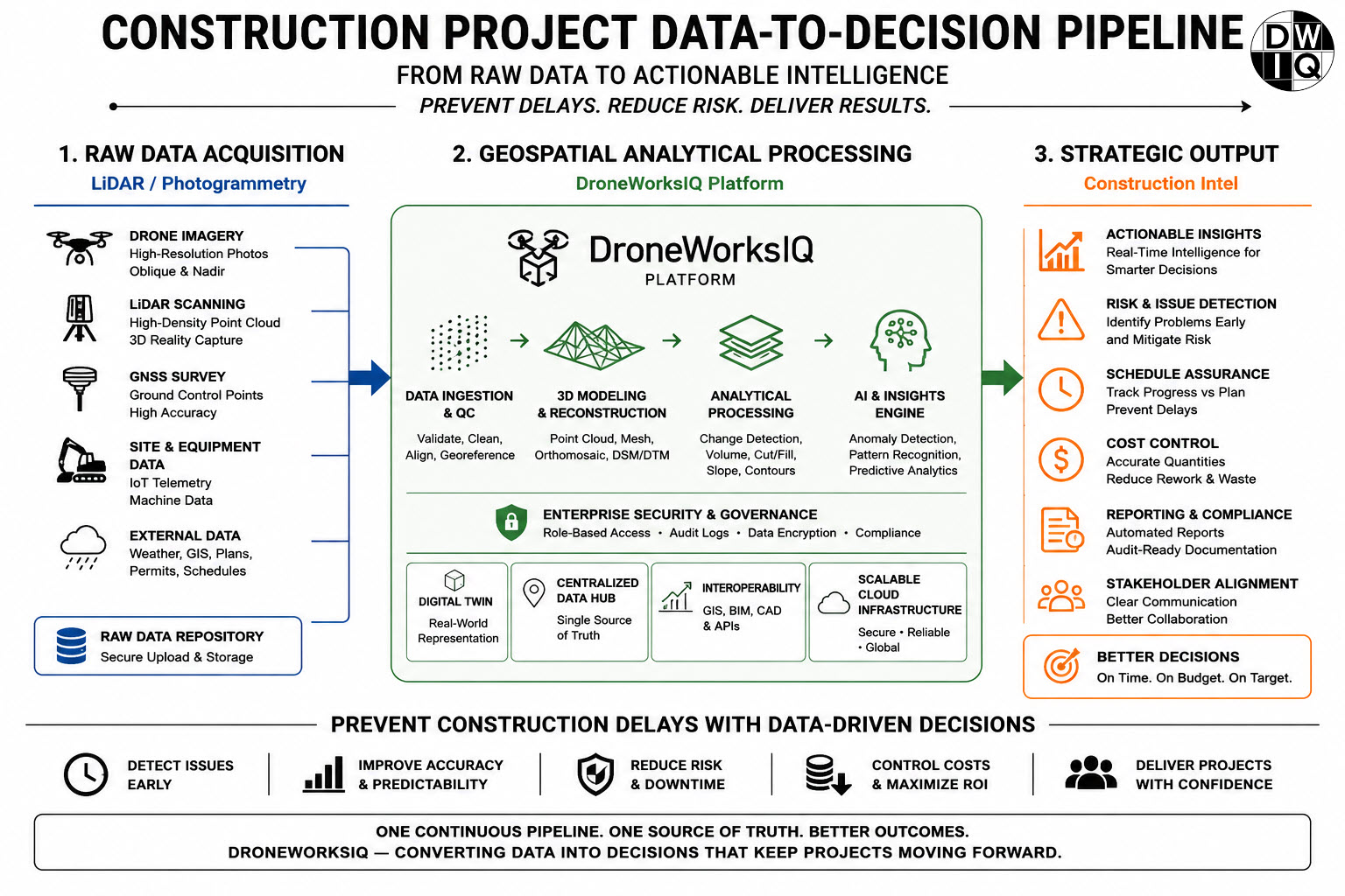
Analyzing the Systemic Drivers of Construction Project Delays
The persistent failure to synchronize project stakeholders with field reality stems from deep-seated information asymmetry. When planning occurs in isolation from current topographical conditions, the resulting systemic drivers of construction project delays manifest as cascading critical path failures. Preventing construction project delays requires a departure from static survey methods that become obsolete within days of ground-breaking. This reliance on outdated or low-fidelity data creates a fundamental disconnect between the digital twin and the physical asset.
Communication silos exacerbate these data gaps. Field teams frequently operate on assumptions that don't align with the office's high-level scheduling; this leads to uncoordinated sequencing. The impact of inaccurate initial surveys acts as a catalyst for early-stage project slippage. Without a centralized hub for truth, preventing construction project delays remains a reactive struggle rather than a proactive strategy. Organizations must prioritize the integration of real-time field intelligence to maintain operational momentum.
The Reality of Information Gaps in Infrastructure
Precision is the prerequisite for efficiency. A seemingly negligible 6-inch discrepancy in site grading can derail subsequent sequencing for utility installation or foundation pouring. Such errors trigger the rework loop. This occurs when structural deviations remain undetected until they conflict with later-stage components. This late-stage detection necessitates demolition and reconstruction. It consumes resources originally allocated for forward progress and forces teams into defensive, corrective workflows.
Economic Consequences of Schedule Slippage
The fiscal impact of delays extends beyond simple timeline extensions. Compounding interest on labor costs and equipment standby fees rapidly erodes project margins. When milestones are missed, the resulting loss of stakeholder confidence can jeopardize future funding or institutional support. By utilizing the DroneWorksIQ platform, organizations replace these uncertainties with engineering intelligence. Every decision is backed by high-fidelity, repeatable evidence that ensures project viability throughout the asset lifecycle.
Establishing Site Certainty via High-Resolution LiDAR and Photogrammetry
Precision mapping serves as the primary mechanism for preventing construction project delays by eliminating topographical ambiguity during the initial planning phases. While traditional methodologies identify broad site features, advanced aerial intelligence provides the point density required for rigorous engineering verification. Light Detection and Ranging (LiDAR) represents the gold standard for high-accuracy terrain and structural analysis, utilizing active sensors to penetrate vegetation and capture intricate geometry that passive sensors often omit. This methodology enables the collection of geospatial data within a 1-inch tolerance, allowing project leads to validate site conditions against strict engineering specifications. Addressing the common causes of construction delays requires moving beyond administrative oversight into the acquisition of high-fidelity, evidence-based data.
Advanced LiDAR Data Collection for Enterprise Projects
The deployment of autonomous systems for aerial LiDAR data collection facilitates the capture of millions of discrete data points across complex industrial environments. These raw pulses undergo systematic processing to generate dense point clouds, which teams then convert into engineering-ready documentation. This transformation from raw signal to actionable 3D models allows for precise volumetric measurements and structural integrity assessments. It ensures that any discrepancy between the design and the physical site is identified before it impacts the critical path.
Photogrammetry for Rapid Progress Visualization
Drone mapping and photogrammetry services leverage high-resolution imagery to produce comprehensive orthomosaic maps of sprawling infrastructure sites. By synthesizing thousands of overlapping images, these 3D models enable the detection of deviations from the original Building Information Modeling (BIM) design. This proactive identification of misalignments is a critical component in preventing construction project delays by ensuring that field reality remains synchronized with the digital blueprint. Organizations seeking to stabilize their project timelines should consider integrating Digital Twinning Services to establish a permanent, high-accuracy record of site evolution.
Strategic Frameworks for Progress Monitoring and Regulatory Compliance
The implementation of a high-fidelity digital record represents a paradigm shift in technical oversight. By establishing a "Digital Twin," stakeholders maintain a living record of project evolution that transcends the limitations of static reporting. This framework is essential for preventing construction project delays by providing a continuous stream of evidence-based data. Systematic progress monitoring ensures that every phase of the asset lifecycle is documented with repeatable accuracy. This methodology includes the automation of volumetric analysis for stockpile measurement and earthwork tracking; this eliminates the manual errors typical of traditional ground-based surveying. Precise earthwork calculations ensure that grading activities remain within design tolerances, preventing the "rework loop" identified in previous sections.
Compliance requirements in 2026 demand more than anecdotal field reports. Regulatory audits require repeatable, high-resolution documentation that proves adherence to engineering specifications. By utilizing autonomous aerial systems, firms generate a comprehensive audit trail that simplifies the verification of site activities. This data-driven approach to preventing construction project delays ensures that all stakeholders operate from a single, verified source of truth, reducing the likelihood of disputes and administrative bottlenecks.
The Infrastructure Digital Twin as a Management Tool
Integrating aerial data into an infrastructure digital twin provides the technical foundation for 4D modeling. This temporal dimension enables historical comparison and trend analysis; project leads can visualize the site as it existed on any specific date. This capability allows for the early identification of schedule deviations, ensuring that corrective measures occur before delays become irreversible. It transforms the digital twin from a passive model into an active management instrument for infrastructure lifecycle oversight.
Autonomous Progress Tracking Workflows
The transition to autonomous monitoring follows a structured three-step protocol designed for industrial scale:
Step 1: Establishing a georeferenced baseline for the entire project site to serve as the primary datum for all future measurements.
Step 2: Conducting recurring construction intel drone surveys to capture high-resolution site status.
Step 3: Utilizing AI-driven analytics to flag discrepancies between "as-built" and "as-designed" states, facilitating immediate engineering intervention.
Achieve total site transparency and mitigate scheduling risks by deploying Digital Twinning Services for your next infrastructure project.
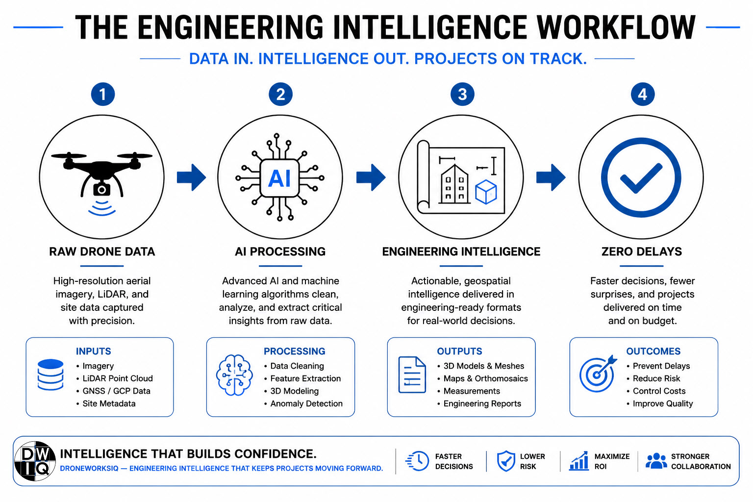
Driving Engineering Outcomes with the DroneWorksIQ Intelligence Platform
The DroneWorksIQ mission operates at the nexus of advanced technology and strategic industrial application; it focuses on the transformation of raw sensor output into actionable engineering intelligence. This methodology replaces the traditional reliance on fragmented site reports with a unified, data-driven framework. By delivering accurate and repeatable evidence, the platform establishes the technical foundation necessary for preventing construction project delays across large-scale infrastructure projects. Strategic geospatial consulting ensures that complex datasets, such as dense LiDAR point clouds, are interpreted through an engineering lens to support high-level corporate decision-making.
Asset lifecycle management extends the utility of this data beyond the initial build phase. The intelligence captured during construction informs ongoing maintenance and operational strategies, ensuring that the initial investment in aerial data collection provides value for decades. This comprehensive oversight mitigates the risks associated with structural degradation and environmental impact, positioning DroneWorksIQ as a critical partner in long-term infrastructure health. By maintaining a continuous record of the asset, organizations can identify potential failures before they necessitate emergency repairs or operational shutdowns.
Actionable Insights for Project Executives
The transition from raw image files to "Construction Intel" executive summaries allows leadership to bypass technical noise and focus on strategic outcomes. This streamlined reporting reduces friction in infrastructure inspection by providing a centralized hub for progress monitoring. Executives gain the ability to track granular developments within 1 inch of tolerance, ensuring that every project milestone adheres to the critical path. This level of oversight fosters stakeholder confidence by providing evidence-based proof of performance at every stage of development.
Key Takeaway
Engineering intelligence eliminates the root causes of construction delays by replacing site uncertainty with high-fidelity, repeatable data that prevents costly rework and stabilizes project timelines.
Operationalizing Site Certainty for Large-Scale Infrastructure
The systematic integration of high-resolution LiDAR and autonomous monitoring cadences effectively eliminates the information gaps that traditionally drive schedule slippage. By establishing a georeferenced baseline and maintaining a living digital twin, project stakeholders transition from speculative planning to evidence-based execution. This framework is the definitive standard for preventing construction project delays, ensuring that field reality and engineering design remain in absolute alignment within 1 inch of tolerance. Organizations that prioritize these technical benchmarks reduce the rework loop and stabilize their operational timelines.
DroneWorksIQ provides the technical architecture required to convert raw aerial captures into strategic Construction Intel. Our engineering-focused drone data platform delivers accurate, repeatable, and evidence-based results through strategic AI-driven geospatial insights. This approach ensures that every site deviation is flagged for immediate intervention, preserving the critical path and maximizing resource efficiency throughout the asset lifecycle. Precision remains the most effective hedge against the complexities of modern industrial development.
Transform your drone data into engineering intelligence with DroneWorksIQ and secure the operational momentum your project requires. Technical clarity is the ultimate catalyst for timely delivery.
Frequently Asked Questions
What are the primary technical causes of construction project delays in 2026?
The primary technical drivers of schedule slippage in 2026 include persistent information asymmetry between stakeholders and a projected labor deficit of 499,000 workers. These factors exacerbate the field-to-office gap, leading to uncoordinated sequencing and late-stage detection of structural deviations. When initial surveys lack the necessary point density, subsequent engineering decisions are based on obsolete topography. This systemic failure in data synchronization is a leading cause of rework and cascading critical path failures.
How does LiDAR technology differ from traditional land surveying in preventing delays?
LiDAR technology utilizes active laser sensors to capture millions of discrete data points, whereas traditional land surveying relies on sparse manual measurements. This high-density geospatial data provides a more comprehensive topographical analysis, particularly in environments with dense vegetation or complex geometry. By automating the capture process, LiDAR eliminates human error and provides a repeatable engineering baseline. This precision is instrumental in preventing construction project delays by ensuring that site grading and utility placement remain within strict design tolerances.
Can drone-based progress monitoring integrate with existing BIM and ERP software?
Modern aerial intelligence frameworks facilitate seamless integration with existing Building Information Modeling (BIM) and Enterprise Resource Planning (ERP) systems. The DroneWorksIQ platform functions as an enterprise framework that exports high-fidelity 3D models and orthomosaics directly into these management environments. This integration allows for real-time comparison between "as-built" reality and "as-designed" digital blueprints. By synchronizing these data streams, project managers identify discrepancies early, facilitating proactive interventions that stabilize the project timeline.
What is the typical accuracy level of aerial photogrammetry for construction sites?
High-resolution aerial photogrammetry typically achieves a positional accuracy within 1 inch of tolerance for large-scale construction sites. This level of precision is achieved through the synthesis of thousands of overlapping images and the use of ground control points or RTK/PPK processing. While photogrammetry is highly effective for rapid 2D orthomosaic generation and 3D visualization, it is often paired with LiDAR to ensure structural integrity across complex vertical surfaces. This combined approach provides the evidence-based data required for rigorous engineering verification.
How does a digital twin facilitate faster regulatory compliance and documentation?
A digital twin functions as a comprehensive, time-stamped record of project evolution, which significantly accelerates the verification of regulatory compliance. By providing a repeatable and evidence-based audit trail, this technology simplifies the submission of documentation for safety and environmental inspections. The use of 4D modeling allows regulators to perform historical comparisons, ensuring that all site activities adhere to permitted specifications. This transparent data environment is a strategic asset for preventing construction project delays caused by administrative bottlenecks or permitting disputes.
Originally published by DroneWorksIQ. Legacy source.