
INSIGHTS
Safe and Efficient Cell Tower Inspections Using Drones
A technical deep-dive into how autonomous UAV systems, terrestrial LiDAR, and AI-driven geospatial analytics are transforming telecommunications asset management.
Table of Contents
The Evolution of Cell Tower Inspection Methodologies
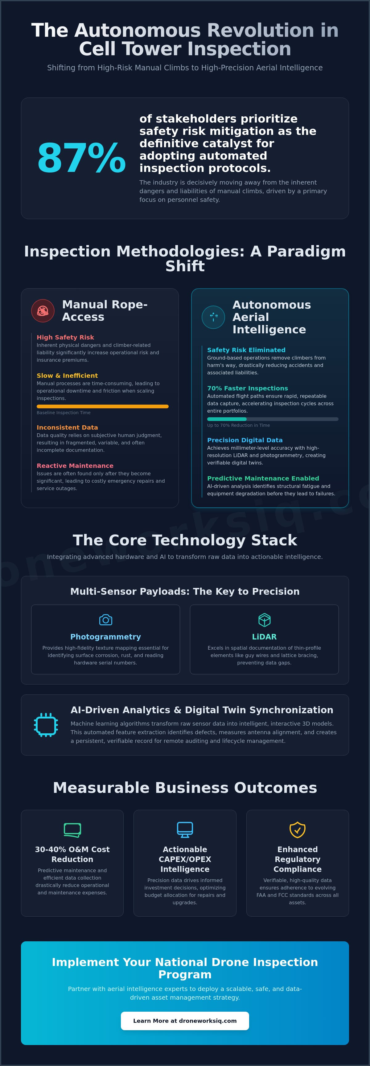
The paradigm for telecommunications infrastructure assessment has shifted from a high-risk manual task to a data-centric, automated process. This evolution is driven by the deployment of autonomous aerial intelligence, a discipline that leverages unmanned aerial vehicles (UAVs) and sophisticated sensor payloads to capture quantitative, high-fidelity geospatial data. This transition marks the obsolescence of manual tower climbs, which are inherently characterized by significant risk profiles, operational downtime, and inconsistent qualitative observations. Modern inspections now focus on creating a comprehensive digital record of the entire asset, from the tower's apex to the ground facility's foundation, ensuring unparalleled accuracy for maintaining structural integrity and meeting rigorous regulatory compliance standards.
From Manual Climbs to Autonomous Data Acquisition
The Strategic Value of Aerial Intelligence
Technical Payloads and Data Acquisition Standards
The quality of a digital twin is directly dependent on the precision of the data acquisition technology. For cell tower inspections, a multi-modal approach combining aerial and terrestrial sensors is required. This involves a synergy between high-resolution photogrammetry, aerial LiDAR, and ground-based LiDAR to capture every facet of the site. Payloads must deliver millimeter-level accuracy for critical measurements like antenna azimuth and tilt, while thermal imaging can identify electrical anomalies. In the challenging, high-wind environments typical of tower locations, advanced payload stabilization and gimbal precision are non-negotiable for acquiring usable data.
Aerial LiDAR vs. Photogrammetry for Tower Modeling
Ground-Based Data Capture for Complete Site Audits
A comprehensive cell tower inspection extends beyond the vertical structure to include a full audit of the ground facility. This is an industry-standard practice utilizing terrestrial survey technology to create a complete operational picture. Using advanced systems like the Matterport Pro 3, technicians can perform 360-degree ground imaging and LiDAR scans to generate interactive virtual walkthroughs and precise 3D recreations of the ground installation. This process documents the as-built condition of all critical ground assets, including:
Sensor Specifications for Enterprise Inspections
AI-Driven Analytics and Digital Twin Synchronization
Raw data from drones and ground scanners is only the first step. The true value is unlocked through AI-driven processing that transforms this data into an intelligent, interactive digital twin of the entire cell site. This process involves automated feature extraction, where machine learning algorithms identify and classify every component, from individual antennas on the tower to specific generator models on the ground. AI-powered defect detection automates the identification of corrosion, bird nests, and equipment misalignment. By synchronizing this data over time, a historical record is created, enabling powerful temporal change detection and forming the foundation of a predictive maintenance strategy.
The Architecture of a Telecommunications Digital Twin
AI and Machine Learning in Infrastructure Intelligence
Centralized Platform Delivery & Commitment to Compliance
Operational Risk Mitigation and Regulatory Compliance
Operating UAVs in the vicinity of active telecommunications towers presents unique technical challenges and regulatory requirements. The high-power transmission environment creates significant Electromagnetic Interference (EMI) that can disrupt drone command-and-control systems. A robust operational plan must include clinical EMI mitigation strategies. Furthermore, all operations must adhere strictly to FAA Part 107 regulations, often requiring specialized waivers for proximity flights. For assets classified as critical national infrastructure, stringent data security protocols are paramount to protect sensitive information from unauthorized access.
Navigating Electromagnetic Interference (EMI)
Enterprise Data Security and Sovereignty
Strategic Implementation of Drone Inspection Programs
Transitioning a national portfolio of cell towers to an autonomous inspection framework requires a strategic, phased approach. The initial phase involves developing a clear roadmap that defines data standards and integration points with existing asset management systems. The selection of an aerial intelligence partner is a critical decision, hinging on their demonstrated capability, AI maturity, and experience with large-scale deployments. A thorough ROI analysis should be conducted, comparing the total cost and time-to-data of an autonomous program against traditional methods. Drone Works IQ provides the comprehensive, scalable aerial infrastructure required to execute such a program effectively.
Scaling from Pilot Projects to National Portfolios
The DroneWorksIQ Advantage in Telecom
Comprehensive Site Modeling: We integrate advanced aerial LiDAR and photogrammetry with terrestrial ground facility scans for a complete digital record.
AI-Driven Analytics: Our platform accelerates decision-making and defect identification through automated, intelligent data analysis.
Consultative Approach: We partner with enterprise clients to develop a consultative strategy for geospatial data integration and program scaling.
CTA:Optimize your infrastructure management with DroneWorksIQ
Originally published by DroneWorksIQ. Legacy source.