
Digital Twin Construction Site: Precision Aerial Intelligence for Enterprise Infrastructure
- Dan

- Jun 5
- 11 min read
Updated: Jun 15
The value of a digital twin is defined by the autonomous frequency and geospatial precision of its aerial data source. While the global digital twin market is projected to reach USD 110.1 billion by 2029, the utility of these systems is often undermined by low-fidelity data inputs. You've likely experienced the friction of data silos and the delays associated with manual progress monitoring on a digital twin construction site. These design-reality gaps result in inaccurate as-built documentation and high rework costs that erode project margins and complicate long-term asset management.
This article outlines a technical framework for deploying drone-based intelligence to achieve real-time visibility and automated volumetric analysis. We'll analyze how the implementation of the BS EN 18162:2026 standard and the latest ISO 19650 updates provide a structured path for integrating LiDAR and photogrammetry into enterprise workflows. You'll learn how to leverage these advanced geospatial tools to reduce site-visit overhead and ensure seamless, data-driven handover deliverables that meet the most rigorous GSA standards for a single source of truth.
Key Takeaways
Distinguish between static 3D visualizations and dynamic digital twins by implementing high-frequency aerial data capture protocols.
Evaluate the technical trade-offs between LiDAR point clouds and photogrammetric meshes to optimize data acquisition for specific site environmental factors.
Streamline the data pipeline from autonomous aerial capture to enterprise BIM platforms to maintain a high-fidelity digital twin construction site.
Quantify the strategic ROI of digital twin deployment through automated variance analysis and high-precision error detection.
Optimize resource allocation and infrastructure oversight by leveraging real-time site intelligence for seamless project handover deliverables.
Defining the Enterprise-Grade Digital Twin in Modern Construction
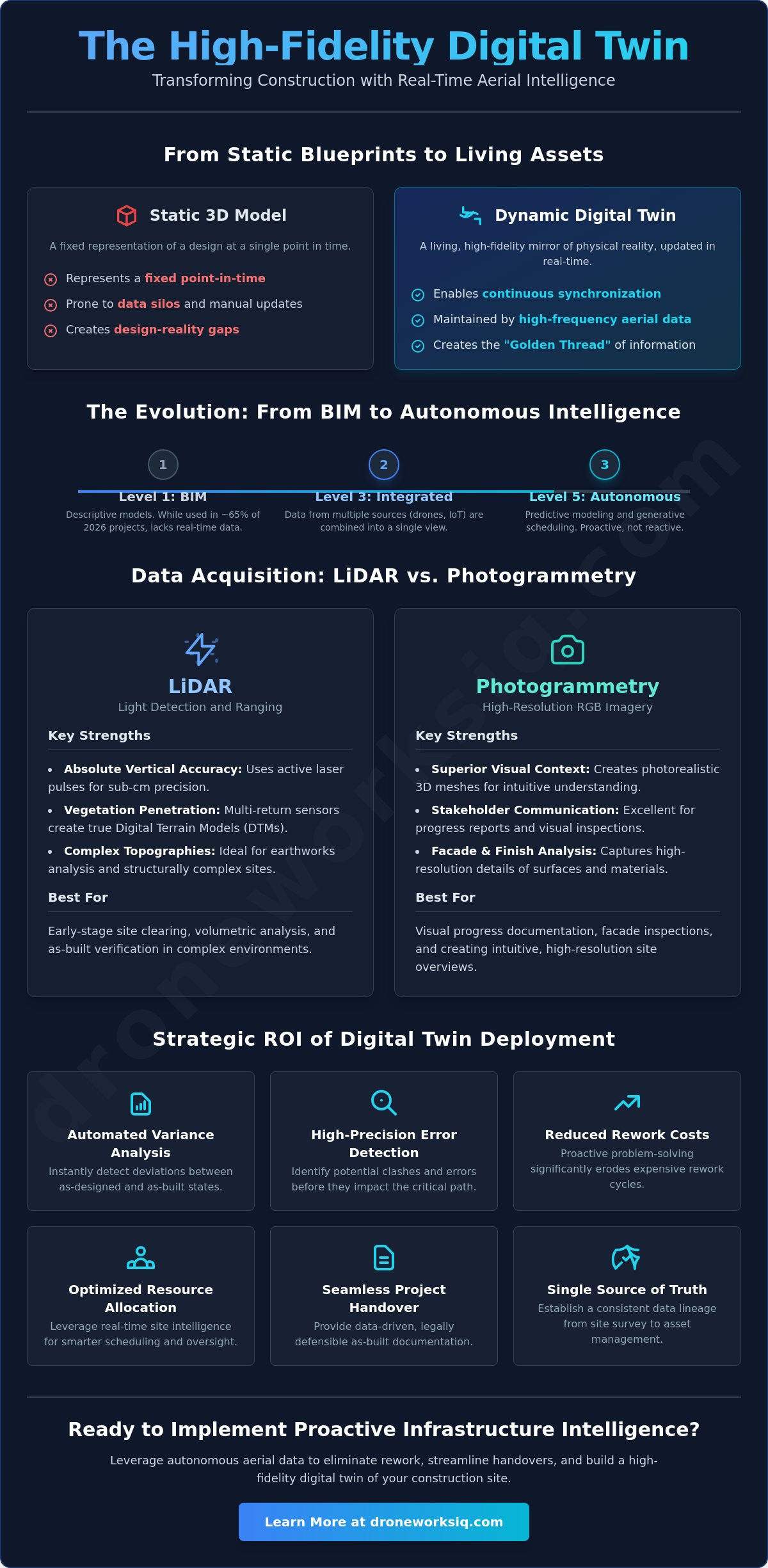
The integration of a Digital Twin within an enterprise framework necessitates a shift from descriptive modeling to active data synthesis. Unlike static 3D models which represent a fixed point in time, a digital twin construction site functions as a dynamic, high-fidelity mirror of physical reality. This distinction remains critical for large-scale infrastructure projects where the rate of physical change exceeds the capacity of traditional manual documentation. Enterprise-grade twins rely on high-frequency aerial data to maintain currency, ensuring that the virtual environment reflects the current state of the physical asset with minimal latency. This continuous synchronization establishes the "Golden Thread" of information, a consistent data lineage that extends from initial site surveys through to long-term asset management and decommissioning. Technical requirements for enterprise-level geospatial accuracy involve the harmonization of LiDAR-derived point clouds with existing Building Information Models, ensuring that the as-built state remains synchronized with the as-designed parameters.
The Evolution from BIM to Autonomous Twins
The industry transition from Building Information Modelling (BIM) to autonomous digital twins represents a move from Level 1 descriptive models to Level 5 autonomous systems. While approximately 65% of construction projects worldwide utilized BIM workflows by 2026, BIM alone lacks the temporal resolution required for real-time progress monitoring. Level 5 twins integrate autonomous aerial intelligence with IoT sensor arrays to enable predictive modeling and generative scheduling. These systems don't just record what's been built; they analyze variances and forecast potential delays before they impact the critical path. This evolution allows project managers to transition from reactive troubleshooting to proactive infrastructure intelligence, utilizing automated data pipelines that eliminate the friction typical of manual site inspections.
Geospatial Precision: The Foundation of Digital Fidelity
Achieving sub-centimeter accuracy within a digital twin construction site requires the rigorous application of Ground Control Points (GCPs) and high-density LiDAR data collection. Without precise geospatial anchoring, virtual models suffer from drift and misalignment, rendering them useless for automated volumetric analysis or interference detection. Engineers must navigate the complexities of global coordinate systems versus local site grids to ensure that every point cloud and mesh is perfectly registered. Digital twin fidelity is the convergence of spatial accuracy and temporal frequency. This technical foundation ensures that the intelligence derived from the twin is both actionable and legally defensible for as-built documentation. High-fidelity twins provide the precision necessary for high-stakes decision-making, where even minor discrepancies in spatial data can lead to significant rework costs and structural conflicts.
Data Acquisition Methodologies: LiDAR vs. Photogrammetry for Construction Twins
Establishing a digital twin construction site requires a calculated choice between active and passive remote sensing technologies. The selection of data acquisition hardware dictates the analytical potential of the resulting progress model. High-fidelity data collection is currently Changing How Infrastructure Is Designed and managed across its entire lifecycle. Enterprise teams must evaluate the technical trade-offs between LiDAR point clouds and photogrammetric meshes to ensure the digital replica serves its intended strategic purpose.
LiDAR: Precision in Complex Topographies
LiDAR (Light Detection and Ranging) provides absolute vertical accuracy by utilizing active laser pulses. This is essential for sites with dense vegetation or complex structural layering. Multi-return LiDAR sensors allow for the penetration of canopy cover to establish a true digital terrain model (DTM). This capability is critical during early-stage site clearing where volumetric analysis of earthworks requires sub-centimeter precision. Processing multi-return data necessitates a methodical approach to noise filtration and ground classification to maintain the integrity of the digital twin construction site.
Photogrammetry: High-Resolution Visual Context
Photogrammetry leverages high-resolution RGB imagery to generate photorealistic meshes. While it offers superior visual context for stakeholder communication and facade inspections, it's limited in low-contrast environments or on highly reflective surfaces like glass and polished metal. Optimizing these models requires specific flight parameters, including high overlap (typically 80% frontal and 80% side) and consistent lighting conditions to ensure maximum mesh fidelity. When visual clarity is the priority for progress documentation, photogrammetry remains the industry standard for providing intuitive, high-resolution site overviews.
Data density is the primary driver for automated feature extraction and AI analysis. Machine learning algorithms require a specific points-per-square-meter threshold to identify structural components like rebar, conduit, or MEP fixtures with high confidence levels. A hybrid data collection strategy often yields the highest ROI for large-scale infrastructure. By combining the structural precision of LiDAR with the visual detail of photogrammetry, organizations gain a comprehensive intelligence layer that supports both technical engineering requirements and high-level project oversight. For organizations requiring specialized LiDAR data collection and analysis, the integration of these methodologies ensures the highest level of geospatial fidelity across the building lifecycle.
Case Study: Implementing Autonomous Aerial Intelligence on Large-Scale Infrastructure
Operationalizing a digital twin construction site requires a structured methodological framework that transitions from raw data acquisition to actionable intelligence. On a recent multi-phase infrastructure project, the primary objective was to establish a high-fidelity digital mirror to mitigate the risks of data silos and inaccurate as-built documentation. By deploying autonomous drone missions for weekly site updates, the project team maintained a continuous stream of geospatial data, allowing for the immediate identification of design-reality gaps. This systematic approach aligns with the BS EN 18162:2026 standard, which provides the necessary definitions and concepts for digital twins in the built environment. The intelligence outcomes derived from this deployment facilitated a shift toward predictive project management, moving beyond the limitations of manual oversight.
Phase 1: Baseline Site Digitization and LiDAR Scanning
The initial phase focused on establishing a primary digital benchmark through high-density LiDAR scanning. This baseline is critical for ensuring that all subsequent progress data remains registered to a precise coordinate system. By integrating this aerial data with the project master BIM file, engineers identified early-stage discrepancies in site grading and utility placement that would've remained undetected through traditional survey methods. This "Single Source of Truth" workflow, as mandated by GSA standards, ensured that all stakeholders operated from identical geospatial parameters. The precision of the LiDAR point cloud established the necessary fidelity for the automated variance analysis used in later stages.
Phase 2: AI-Driven Progress Monitoring and Volumetric Tracking
Phase two introduced autonomous aerial missions to track stockpile volumes and earthwork movement without manual intervention. AI analytics processed the weekly data streams to identify structural elements against the planned construction schedule. This automation allowed for the generation of delta reports that quantified the exact progress of concrete pours and steel erection. By utilizing a Common Data Environment (CDE), the project team reduced rework by identifying deviations in real-time. Industry research indicates that implementing digital twins can lead to a 10-20% reduction in operating costs through improved predictive maintenance and performance monitoring. This level of oversight ensured project timeline adherence while maintaining strict stakeholder alignment through transparent, data-driven reporting.
This data-driven approach is equally critical for navigating regulatory requirements during the planning phase. For developers seeking expert guidance on transport planning, visit ML Traffic Engineers Australia to see how impact assessments are conducted.
Overcoming Integration Friction: Connecting Geospatial Data to BIM Ecosystems
Integrating raw geospatial data into enterprise Building Information Modeling (BIM) software requires a systematic approach to data transformation and ingestion. The primary friction point in maintaining a digital twin construction site isn't the raw data acquisition. It's the conversion of unstructured point clouds into intelligent, parametric objects within a Common Data Environment (CDE). To learn how specialized firms handle these complex workflows, discover CRAYDL and their BIM/VDC expertise. Automating this data pipeline ensures that aerial intelligence moves from the sensor to the decision-maker without the latency of manual processing. Large-scale infrastructure projects frequently generate multi-terabyte datasets that overwhelm standard desktop hardware. Enterprise strategies must prioritize cloud-native processing to manage these volumes without compromising system performance. These systems facilitate multi-stakeholder collaboration while maintaining the rigorous data security and encryption standards necessary for high-stakes industrial applications.
Standardizing Data Formats for Interoperability
Maintaining the "Golden Thread" of information requires strict adherence to open-standard formats like Industry Foundation Classes (IFC). This ensures that critical metadata persists across the entire data lifecycle, from initial site survey to final asset handover. To prevent software latency, technical teams must implement point cloud decimation strategies that reduce redundant point density without sacrificing the spatial accuracy required for desktop BIM applications. This optimization allows for seamless interference detection and variance analysis within existing design environments. Standardizing these formats is essential for the interoperability between raw drone data and complex infrastructure intelligence platforms.
Real-Time Collaboration via Infrastructure Intelligence Platforms
Centralized, browser-based access to digital twins provides a strategic advantage by democratizing geospatial intelligence across the project team. This shared virtual site access significantly reduces Request for Information (RFI) cycles. Stakeholders can verify site conditions remotely with sub-centimeter precision, eliminating the need for redundant site visits. National-level project oversight is enhanced through remote inspection protocols, allowing technical leads to monitor multiple sites simultaneously from a single interface. This streamlined communication rhythm ensures that the digital twin remains an active tool for project velocity rather than a static archive. It's a shift from reactive data management to proactive site oversight.
For enterprises seeking to eliminate integration friction, our digital twinning services provide the technical framework necessary for high-fidelity infrastructure intelligence.
The Strategic ROI of Digital Twin Deployment: From Progress Monitoring to Handover
The deployment of a digital twin construction site represents a strategic capital investment aimed at maximizing lifecycle efficiency through high-fidelity data synthesis. Financial returns are realized primarily through the systematic quantification of variances between the as-designed BIM and the as-built reality. Early detection of these discrepancies through automated variance analysis prevents the compounding of errors that typically leads to expensive downstream rework. Beyond immediate site oversight, these models optimize resource allocation and logistics by providing precise intelligence on material consumption and equipment utilization. This methodical approach to data management transforms construction from a series of disjointed phases into a continuous, data-driven operation with measurable financial outcomes.
Reducing Rework and Mitigation Costs
Industry benchmarks suggest that digital twins can lead to a 10-20% reduction in operating costs through predictive maintenance and performance monitoring. This reduction in operational friction directly impacts the project bottom line by minimizing the financial leakage associated with design-reality gaps. Automated design-reality checks provide a documented history of compliance that improves risk management profiles and influences insurance premiums for large-scale builds. The ability to demonstrate a "Single Source of Truth" through verified geospatial data reduces the liability associated with structural failures or design omissions. By implementing these rigorous analytical protocols, enterprise teams ensure that every dollar spent on data acquisition generates a significant return in risk mitigation and operational velocity.
Streamlining Project Handover and Lifecycle Management
Project handover marks the transition from a dynamic digital twin construction site to a permanent asset record, yet the value of the twin persists into the facility management phase. Providing building owners with a high-fidelity digital record ensures that future maintenance and renovations are informed by accurate as-built data. This "Golden Thread" of information is essential for long-term asset integrity monitoring. Integrating the construction twin into existing Enterprise Asset Management (EAM) systems allows for the automation of maintenance schedules based on real-world conditions rather than theoretical lifecycles. Digital Twin Services by DroneWorksIQ enable seamless data transitions for long-term asset health, ensuring that the intelligence gathered during construction remains accessible and actionable throughout the building's operational life. This lifecycle approach to digital twinning moves beyond simple project oversight, establishing a foundation for sustainable, high-performance infrastructure management.
Operationalizing Infrastructure Intelligence Through Digital Synthesis
The transition from descriptive modeling to autonomous progress monitoring represents a fundamental evolution in infrastructure lifecycle management. Maintaining a high-fidelity digital twin construction site requires the rigorous application of specialized LiDAR and photogrammetric methodologies to ensure sub-centimeter geospatial accuracy. By automating the data pipeline from aerial capture to enterprise BIM platforms, organizations eliminate the friction of data silos and mitigate the substantial costs associated with design-reality gaps. This technical framework provides the necessary oversight to secure project margins and ensure long-term asset integrity through every phase of development.
Achieving this level of precision demands a strategic partner with the analytical depth to handle complex, high-stakes data environments. Optimize Your Infrastructure Oversight with DroneWorksIQ Aerial Intelligence. Our specialized LiDAR and photogrammetry expertise, combined with enterprise-grade AI geospatial analytics and national-scale deployment capabilities, ensures your projects remain synchronized with reality. Implement these advanced systems to drive efficiency and maintain comprehensive oversight of your most critical assets.
Frequently Asked Questions
What is the difference between BIM and a digital twin in construction?
BIM serves as a foundational geometric and semantic framework for design and construction, whereas a digital twin construction site operates as a dynamic, synchronized replica of physical reality. While BIM focuses on the design and execution process, the digital twin integrates real-time data streams to provide a continuous feedback loop between the physical asset and its virtual counterpart. This distinction is critical for maintaining high-fidelity site oversight throughout the building lifecycle.
How often should a digital twin construction site be updated?
Update frequency is dictated by project velocity and the specific requirements for automated progress monitoring. High-stakes infrastructure projects typically require weekly aerial data acquisition to ensure the digital twin remains synchronized with the rapid pace of physical change. This cadence allows for the timely identification of design-reality variances and ensures that decision-makers operate from the most current geospatial intelligence available during the construction phase.
What drone sensors are best for creating a construction digital twin?
High-precision digital twins require a combination of LiDAR and high-resolution RGB sensors. LiDAR is essential for establishing absolute vertical accuracy and penetrating site obstructions to create detailed digital terrain models. RGB sensors facilitate photogrammetric mesh generation, providing the visual context necessary for facade inspections and stakeholder communication. Hybrid sensor strategies maximize the analytical depth and fidelity of the resulting progress models.
Can digital twins be integrated with existing project management software?
Integration is achieved through Common Data Environments and robust API protocols that connect geospatial data to enterprise project management systems. This connectivity allows for the automation of progress reports and the direct alignment of site intelligence with project schedules. By centralizing these data streams, organizations reduce RFI cycles and improve the efficiency of multi-stakeholder collaboration on complex infrastructure builds.
How accurate is a drone-based digital twin for construction surveying?
Drone-based digital twins achieve sub-centimeter horizontal and vertical accuracy when supported by Ground Control Points or Real-Time Kinematic positioning. This level of precision meets the rigorous requirements for construction surveying and automated volumetric analysis. Maintaining this accuracy is essential for ensuring that as-built documentation remains legally defensible and technically synchronized with the original design parameters throughout the project.
What are the primary data security concerns for digital twin construction sites?
Primary security concerns involve the protection of multi-terabyte datasets through end-to-end encryption and granular access control. Enterprise infrastructure projects necessitate secure cloud environments that comply with national data sovereignty regulations and industry-specific security standards. Ensuring the integrity and confidentiality of geospatial data is paramount for maintaining stakeholder trust and protecting sensitive site intelligence throughout the entire project lifecycle.
How does a digital twin reduce construction project costs?
Digital twins reduce costs by preventing the compounding of errors through early variance detection and automated design-reality checks. Industry research indicates that implementing these systems can lead to a 10-20% reduction in operating costs through predictive maintenance and performance monitoring. These savings are realized by minimizing rework, optimizing resource allocation, and reducing the overhead associated with manual site inspections.
What is required to transition from a construction twin to an operational twin?
Transitioning requires the handover of high-fidelity as-built data into Enterprise Asset Management or operations and maintenance systems. This process involves the persistence of critical metadata and the standardization of data formats like IFC to ensure long-term interoperability. The construction twin serves as the foundational record for the asset digital lifecycle, enabling continuous health monitoring and predictive maintenance strategies after project completion.


