Drone Thermal Imaging Inspection: An Enterprise Reference for Asset Intelligence (2026)
- Dan

- Jul 12
- 7 min read
Updated: Jul 15
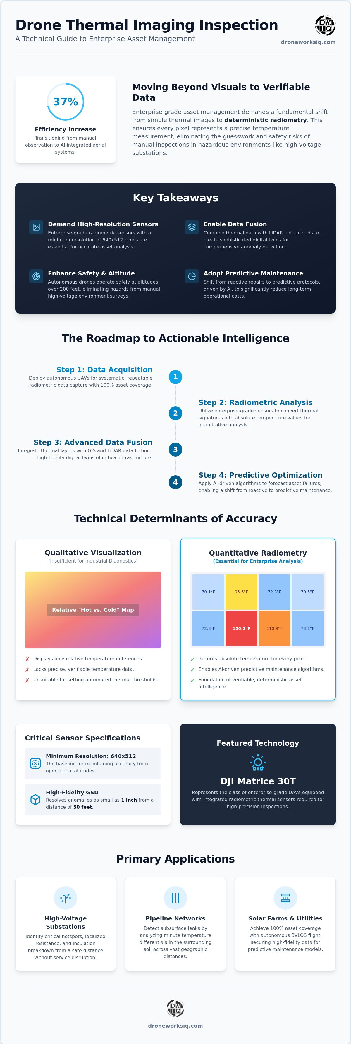
Industrial inspection efficiency increases by nearly 37% when transitioning from manual observation to AI-integrated aerial systems, but the mere capture of thermal signatures is insufficient for enterprise-grade asset management. A professional drone thermal imaging inspection requires a shift from qualitative visualization to deterministic radiometry, eliminating the inaccuracies inherent in consumer-grade sensors. Enterprise decision-makers recognize that manual inspections in high-voltage environments introduce unacceptable safety risks and data inconsistencies that jeopardize infrastructure integrity. Integrating these complex datasets into existing GIS platforms or high-fidelity digital twins remains a significant barrier to achieving comprehensive oversight.
This technical reference establishes the criteria for evaluating and scaling autonomous thermal protocols across critical infrastructure. You'll gain a comprehensive understanding of the sensor specifications, such as the 640x512 pixel minimum resolution required for radiometric accuracy, and the methodology for detecting subsurface structural anomalies. We provide a methodical roadmap for converting raw thermal data into actionable asset intelligence. This guide ensures your maintenance programs move from reactive repairs to predictive optimization through high-precision data fusion and autonomous repeatability.
The Strategic Necessity of Drone Thermal Imaging Inspection for Infrastructure
A drone thermal imaging inspection represents the systematic acquisition of radiometric data to identify precise temperature variances across critical infrastructure surfaces. Unlike standard visual photography, this methodology relies on the Principles of Thermography to convert infrared radiation into absolute temperature values. This capability allows engineers to visualize thermal anomalies that remain invisible to the human eye, providing a deterministic layer of asset intelligence. The transition from qualitative imagery to quantitative radiometric data is fundamental for enterprise-level decision-making; it replaces subjective visual interpretation with verifiable thermal measurements.
Traditional manual thermography often requires technicians to operate at ground level or utilize handheld sensors in proximity to hazardous components. Modern autonomous UAV systems eliminate these constraints, scanning assets from heights exceeding 200 feet with consistent accuracy. This aerial perspective provides a comprehensive overview of large-scale systems, ensuring that early-stage anomalies are identified before they escalate into catastrophic failures. The shift toward autonomous platforms ensures that data collection remains repeatable and objective across multiple inspection cycles.
For property owners who require this level of technical oversight when managing their portfolios, you can visit ScanReal to explore expert commercial property brokerage and management services.
Mitigating Risk in High-Voltage and Pipeline Environments
Aerial thermal scanning identifies critical hotspots in electrical substations without the operational disruption of circuit de-energization. By detecting localized resistance or insulation breakdown from a safe distance, utilities maintain continuous service while identifying maintenance requirements. Similarly, specialized sensors detect subsurface leaks in national pipeline networks by analyzing temperature differentials in the surrounding soil. For comprehensive corridor management, organizations utilize drone pipeline inspection services to integrate thermal data with broader geospatial analytics, ensuring the integrity of midstream assets across vast geographic distances.
Autonomous Scanning and BVLOS Operations
Beyond Visual Line of Sight (BVLOS) capabilities allow for wide-area thermal surveys that were previously cost-prohibitive. Autonomous flight paths ensure 100% asset coverage, removing the variability of manual pilot control. This systematic approach guarantees that every square inch of a solar farm or utility line is documented, providing the high-fidelity data needed for predictive maintenance models. By automating the capture process, enterprises achieve a level of operational efficiency that traditional methods can't match, securing the data density required for advanced infrastructure analysis.
Technical Determinants of Radiometric Accuracy in Aerial Inspections
The efficacy of a drone thermal imaging inspection depends entirely on the distinction between qualitative visualization and quantitative radiometric data collection. Non-radiometric cameras merely display relative temperature differences across a scene, which is insufficient for industrial diagnostics. Professional enterprise applications require radiometric sensors that record the absolute temperature value of every pixel. This deterministic approach enables the identification of specific thermal thresholds that indicate component degradation or structural compromise. Precise temperature measurement is the foundation of AI-driven predictive maintenance, where automated algorithms analyze thermal gradients to forecast asset failure with high statistical confidence.
Sensor Specifications and Data Fidelity
Data fidelity during a drone thermal imaging inspection is governed by sensor resolution and pixel pitch. High-resolution sensors, specifically those featuring a 640x512 pixel microbolometer array, are the baseline requirement for maintaining accuracy from operational altitudes. This pixel density ensures a Ground Sampling Distance (GSD) capable of resolving anomalies as small as 1 inch from a standoff distance of 50 feet. Lower-resolution sensors often suffer from pixel averaging; the heat of a small hotspot is diluted by the cooler surrounding area, leading to false-negative reports. Long-wave infrared (LWIR) sensors are prioritized for infrastructure due to their ability to penetrate atmospheric interference and resolve subtle thermal signatures. Radiometric accuracy is defined as the capability of a sensor to assign a precise, calibrated temperature value to every individual pixel within the captured frame.
Environmental Variables: Emissivity and Delta T Optimization
Accurate thermal analysis requires the calculation of emissivity, which is the efficiency with which a specific surface material emits thermal radiation. Materials with low emissivity, such as polished metals or glass, reflect ambient thermal energy and can produce misleading data if not properly compensated for during processing. This is particularly critical during a building facade drone survey, where varying cladding materials exhibit diverse thermal behaviors. Delta T, or the temperature differential between an asset and its environment, remains the primary indicator of structural or electrical anomalies. Identifying these deltas allows for the prioritization of maintenance tasks based on the severity of the thermal signature. Organizations seeking to implement these advanced protocols should consider consulting with specialized geospatial analysts to ensure sensor calibration aligns with specific asset materials.
Deployment Frameworks: From Raw Thermal Data to AI-Driven Insights
The execution of a drone thermal imaging inspection follows a structured operational sequence designed to transform raw sensor output into deterministic asset intelligence. This process begins with autonomous flight path orchestration, ensuring consistent overlap and nadir positioning for accurate 2D thermal orthomosaic generation. Unlike standard visual mapping, radiometric processing requires the alignment of temperature metadata with geospatial coordinates to facilitate precise spatial analysis. The resulting datasets are not merely images; they are high-density information layers that reveal the internal thermal state of infrastructure components. Standardized metadata is essential for long-term temporal analysis, allowing engineers to track degradation patterns across the asset's operational lifecycle.
Integrating Thermal Layers into Infrastructure Digital Twins
Modern asset management utilizes thermal data as the metabolic layer of a comprehensive digital twin. By fusing radiometric maps with LiDAR-derived point clouds, engineers create multi-dimensional models that visualize heat stress or energy loss within a precise spatial context. This integration allows for the identification of anomalies, such as localized resistance in a substation or insulation failure in a facade, within the broader geometry of the physical asset. Organizations can leverage Digital Twinning Services to maintain a continuous, spatially accurate record of thermal performance.
AI-Powered Anomaly Detection and Automated Reporting
Artificial intelligence serves as a critical filter for the massive data volumes generated during large-scale utility inspections. Machine learning algorithms are trained to distinguish between genuine thermal defects and specular reflections, such as solar glare on metallic surfaces, which frequently produce false positives in manual reviews. These systems automatically flag temperature deviations exceeding pre-defined thresholds, significantly reducing the human-led processing bottleneck. Enterprise-grade reports then prioritize maintenance tasks based on a severity matrix, ensuring that critical structural or electrical failures are addressed before they result in unplanned outages. This automated workflow ensures that every anomaly is categorized with high statistical confidence, moving maintenance from reactive to predictive models.
Infographic Direction:
Title: Thermal Asset Intelligence Workflow. Design a clean visual with a white background and high-contrast black text. Illustrate the process from raw radiometric capture to AI-driven anomaly detection and final integration into a high-fidelity digital twin. Contrast the data density of autonomous aerial scans against traditional ground-based manual thermography.
Optimizing Infrastructure Integrity Through Autonomous Thermal Intelligence
The evolution of asset management necessitates a transition from manual observation to deterministic radiometric data. High-resolution sensors and autonomous flight protocols ensure that every thermal signature is captured with geospatial precision, providing the necessary foundation for advanced digital twinning. By leveraging AI-driven feature extraction, enterprises can effectively filter environmental noise and prioritize maintenance tasks based on quantifiable heat stress and structural anomalies. This systematic approach to a drone thermal imaging inspection transforms raw infrared radiation into actionable insights, securing the long-term reliability of national utility and pipeline networks.
DroneWorksIQ provides national enterprise service coverage, specializing in the complex fusion of multi-sensor LiDAR and thermal data. Our advanced AI-driven geospatial analytics integration allows for the seamless transformation of aerial data into high-fidelity infrastructure intelligence. Consult with DroneWorksIQ on your next enterprise thermal inspection project to establish a predictive maintenance framework that mitigates risk and optimizes operational expenditure. Achieving comprehensive asset oversight is now a deterministic outcome of advanced aerial technology.
Frequently Asked Questions
What is the typical accuracy of an enterprise drone thermal imaging inspection?
Enterprise-grade radiometric sensors typically achieve a thermal accuracy of within +/- 3.6 degrees Fahrenheit or 5 percent of the absolute temperature reading. This precision is contingent upon the use of high-resolution sensors, such as the 640x512 pixel arrays, which maintain data fidelity from operational altitudes. Accurate calibration ensures that the drone thermal imaging inspection provides deterministic results suitable for industrial diagnostics rather than mere qualitative visualization.
How does emissivity affect the results of a building facade drone survey?
Emissivity determines the efficiency with which a surface emits thermal radiation; low-emissivity materials like glass or polished aluminum reflect ambient thermal energy and potentially skew data. During a building facade drone survey, analysts must compensate for these varying material properties to prevent false-positive anomaly detection. Precise emissivity adjustments are critical for distinguishing between a genuine structural defect and a simple reflection of the sun or the surrounding environment.
Can thermal drones detect subsurface pipeline leaks or moisture ingress?
Thermal drones detect subsurface pipeline leaks or moisture ingress by identifying localized temperature differentials caused by fluid escaping or the evaporative cooling of saturated materials. While sensors don't penetrate solid surfaces, they visualize the thermal footprint of subsurface anomalies as they manifest on the top layer of soil or cladding. This capability is essential for identifying insulation failure or pipeline compromise before structural damage becomes visible to the naked eye.
What is the difference between radiometric and non-radiometric thermal sensors?
Radiometric sensors capture absolute temperature values for every individual pixel in the frame, whereas non-radiometric cameras only display relative temperature differences. This distinction is fundamental for enterprise applications where precise thresholds determine maintenance priority. A drone thermal imaging inspection utilizing non-radiometric hardware lacks the quantitative data necessary for AI-driven predictive maintenance or historical asset benchmarking, rendering it insufficient for critical infrastructure oversight.
How does DroneWorksIQ integrate thermal data into an infrastructure digital twin?
DroneWorksIQ integrates thermal data into an infrastructure digital twin by spatially aligning radiometric orthomosaics with high-density LiDAR point clouds. This multi-sensor fusion creates a comprehensive three-dimensional model where thermal signatures are mapped directly onto the asset's geometry. By applying AI-driven feature extraction, we transform raw temperature data into a deterministic metabolic layer that identifies heat stress and energy loss within a precise spatial context.