Safe and Efficient Cell Tower Inspections Using Drones
- Dan

- Jun 3
- 6 min read
Updated: Jun 10
A technical deep-dive into how autonomous UAV systems, terrestrial LiDAR, and AI-driven geospatial analytics are transforming telecommunications asset management.
Table of Contents
The Evolution of Cell Tower Inspection Methodologies
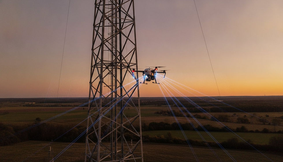
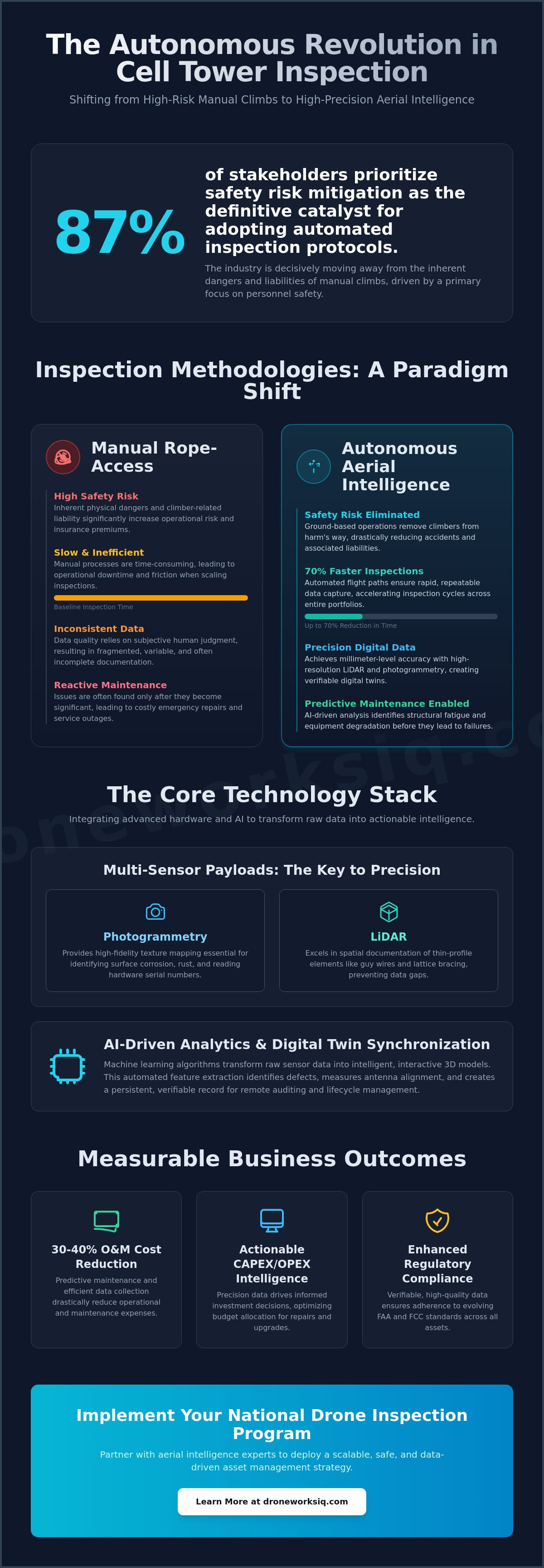
The paradigm for telecommunications infrastructure assessment has shifted from a high-risk manual task to a data-centric, automated process. This evolution is driven by the deployment of autonomous aerial intelligence, a discipline that leverages unmanned aerial vehicles (UAVs) and sophisticated sensor payloads to capture quantitative, high-fidelity geospatial data. This transition marks the obsolescence of manual tower climbs, which are inherently characterized by significant risk profiles, operational downtime, and inconsistent qualitative observations. Modern inspections now focus on creating a comprehensive digital record of the entire asset, from the tower's apex to the ground facility's foundation, ensuring unparalleled accuracy for maintaining structural integrity and meeting rigorous regulatory compliance standards.
From Manual Climbs to Autonomous Data Acquisition
Comparative analysis of inspection speed: Traditional multi-day climbs are replaced by autonomous aerial and terrestrial data capture missions completed in a matter of hours.
Reduction of human error: Standardized, repeatable flight paths and automated scanning protocols eliminate the variability and subjectivity of manual inspections.
Impact on personnel safety: Removing the need for climbers to work at height drastically reduces risk and positively impacts organizational liability insurance structures.
The Strategic Value of Aerial Intelligence
Defining "Actionable Intelligence": Transforming raw data from aerial and ground sensors into precise, verifiable metrics that inform the telecom asset lifecycle.
Informing Capital and Operational Expenditures: High-resolution data provides a clear basis for CAPEX and OPEX decisions, enabling predictive maintenance and targeted upgrades.
System Integration: Seamlessly integrating comprehensive aerial and ground data into existing Enterprise Resource Planning (ERP) and Asset Management Systems (AMS).
Technical Payloads and Data Acquisition Standards
The quality of a digital twin is directly dependent on the precision of the data acquisition technology. For cell tower inspections, a multi-modal approach combining aerial and terrestrial sensors is required. This involves a synergy between high-resolution photogrammetry, aerial LiDAR, and ground-based LiDAR to capture every facet of the site. Payloads must deliver millimeter-level accuracy for critical measurements like antenna azimuth and tilt, while thermal imaging can identify electrical anomalies. In the challenging, high-wind environments typical of tower locations, advanced payload stabilization and gimbal precision are non-negotiable for acquiring usable data.
Aerial LiDAR vs. Photogrammetry for Tower Modeling
Technical advantages of LiDAR: Excels in capturing the precise geometry of thin structural elements, such as lattice structures and guy wires, which are often challenging for photogrammetry algorithms.
Photogrammetry for visual fidelity: Provides high-resolution texture mapping essential for visual defect identification, such as identifying corrosion, rust, and the condition of coatings.
Hybrid data collection: The fusion of LiDAR point clouds with photogrammetric meshes represents the gold standard, creating a digital twin that is both geometrically precise and visually rich.
Ground-Based Data Capture for Complete Site Audits
A comprehensive cell tower inspection extends beyond the vertical structure to include a full audit of the ground facility. This is an industry-standard practice utilizing terrestrial survey technology to create a complete operational picture. Using advanced systems like the Matterport Pro 3, technicians can perform 360-degree ground imaging and LiDAR scans to generate interactive virtual walkthroughs and precise 3D recreations of the ground installation. This process documents the as-built condition of all critical ground assets, including:
Communications hardware, cabling, and connection points
Equipment cabinets and shelters
Backup power systems and generators
Perimeter security, including fencing and access gates
Mandated safety and regulatory signage
Sensor Specifications for Enterprise Inspections
Minimum resolution requirements: Sensor resolution must be sufficient to clearly identify small-scale defects like loose bolts, hairline structural cracks, and early-stage corrosion.
The necessity of RTK/PPK positioning: Real-Time Kinematic or Post-Processed Kinematic GPS data is essential for achieving the absolute geospatial accuracy required for engineering-grade models.
Multi-spectral sensor applications: These sensors can be deployed for ancillary site analysis, such as environmental assessments and monitoring ground erosion around the tower base.
AI-Driven Analytics and Digital Twin Synchronization
Raw data from drones and ground scanners is only the first step. The true value is unlocked through AI-driven processing that transforms this data into an intelligent, interactive digital twin of the entire cell site. This process involves automated feature extraction, where machine learning algorithms identify and classify every component, from individual antennas on the tower to specific generator models on the ground. AI-powered defect detection automates the identification of corrosion, bird nests, and equipment misalignment. By synchronizing this data over time, a historical record is created, enabling powerful temporal change detection and forming the foundation of a predictive maintenance strategy.
The Architecture of a Telecommunications Digital Twin
Data processing pipelines: Establishing automated workflows to process raw aerial and terrestrial data into unified, cloud-based 3D visualizations.
Fusing data sources: Integrating aerial point clouds with ground-based LiDAR scans and 360-degree imagery to create a single, comprehensive site model.
Variance analysis: Comparing the as-built digital twin against original CAD designs to automatically flag discrepancies and deviations.
Virtual site audits: Enabling remote engineering reviews, stakeholder collaboration, and maintenance planning without the need for physical site visits.
AI and Machine Learning in Infrastructure Intelligence
Training neural networks: Developing and training algorithms for specific telecommunications equipment identification, ensuring accurate inventory and asset tracking.
Automating "Close-Out" reports: Utilizing AI to intelligently validate that as-built conditions match work orders, dramatically accelerating the close-out reporting process.
Reducing "Data Noise": Applying algorithms to filter and prioritize information, allowing engineering teams to focus on the most critical structural and operational concerns.
Centralized Platform Delivery & Commitment to Compliance
Unified Delivery Platform: Many tower property & management organizations have proprietary platforms for uploading imagery, maintaining secure access credentials, logging access, logging activity, etc..
Inspection Delivery Evidence: Some organizations do not maintain online portals for unifying all activities and notes. They may prefer secure online data storage options such as Dropbox , Box , Google Drive , or similar enterprise storage options.
Analytical Platforms: For organizations in need of online tools & analytics, Drone Works IQ supports a multitude of online delivery platforms for analysis, 3D modeling, image analysis and more (including but not limited to: DroneDeploy, ArcGIS, MetaShape, CloudCompare, Optelos, MeshLab, RealityScan , Nira , etc..)
100% Compliance Training: Drone Works IQ conforms to every clients delivery requirements with a commitment of 100% of all technicians are 'trained & proficient' as 'qualified' to leverage any client platform.
Operational Risk Mitigation and Regulatory Compliance
Operating UAVs in the vicinity of active telecommunications towers presents unique technical challenges and regulatory requirements. The high-power transmission environment creates significant Electromagnetic Interference (EMI) that can disrupt drone command-and-control systems. A robust operational plan must include clinical EMI mitigation strategies. Furthermore, all operations must adhere strictly to FAA Part 107 regulations, often requiring specialized waivers for proximity flights. For assets classified as critical national infrastructure, stringent data security protocols are paramount to protect sensitive information from unauthorized access.
Navigating Electromagnetic Interference (EMI)
Technical shielding requirements: Enterprise-grade UAVs must feature specialized shielding for internal compasses (magnetometers) and GPS modules to prevent signal degradation.
Operational standoff distances: Calculating safe flight distances based on the tower's transmission frequencies and output power is a critical pre-flight planning step.
Redundant system protocols: Utilizing drones with redundant Inertial Measurement Units (IMUs) and communication links ensures stable flight control in high-interference zones.
Enterprise Data Security and Sovereignty
Encryption standards: Implementing end-to-end AES-256 encryption for all data, both in transit from the drone and at rest in cloud storage.
Compliance with security protocols: Adhering to national security standards for the handling and storage of data related to critical infrastructure.
Managing access controls: Utilizing platform tools that allow for granular, role-based access controls for internal teams, contractors, and other stakeholders.
Strategic Implementation of Drone Inspection Programs
Transitioning a national portfolio of cell towers to an autonomous inspection framework requires a strategic, phased approach. The initial phase involves developing a clear roadmap that defines data standards and integration points with existing asset management systems. The selection of an aerial intelligence partner is a critical decision, hinging on their demonstrated capability, AI maturity, and experience with large-scale deployments. A thorough ROI analysis should be conducted, comparing the total cost and time-to-data of an autonomous program against traditional methods. Drone Works IQ provides the comprehensive, scalable aerial infrastructure required to execute such a program effectively.
Scaling from Pilot Projects to National Portfolios
Standardizing data outputs: Ensuring consistent data formats and report structures for both aerial and ground assets across all regions and tower types.
Centralizing geospatial data: Creating a single source of truth by consolidating all site data into a unified platform for portfolio-wide oversight and analysis.
Integrating with Maintenance Management Systems (MMS): Establishing API connections to push actionable insights and work orders directly from the digital twin platform into existing MMS workflows.
The DroneWorksIQ Advantage in Telecom
Comprehensive Site Modeling: We integrate advanced aerial LiDAR and photogrammetry with terrestrial ground facility scans for a complete digital record.
AI-Driven Analytics: Our platform accelerates decision-making and defect identification through automated, intelligent data analysis.
Consultative Approach: We partner with enterprise clients to develop a consultative strategy for geospatial data integration and program scaling.
CTA:Optimize your infrastructure management with DroneWorksIQ