
Infrastructure Digital Twin: A Strategic Framework for Enterprise Asset Intelligence
- Dan

- 4 days ago
- 8 min read
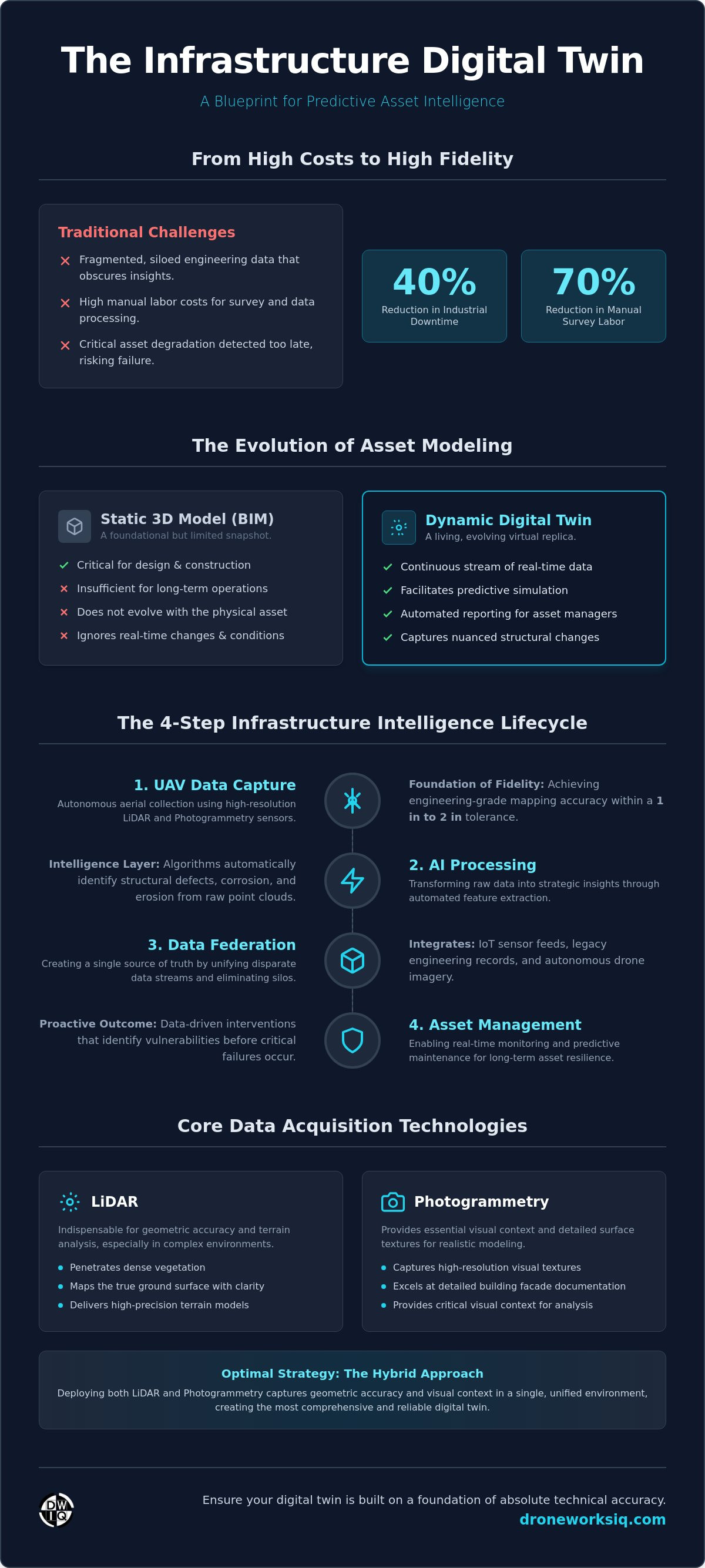
By June 2026, the global digital twin market has reached a valuation of $53.60 billion, reflecting a systemic shift toward data-centric industrial management. Many technical decision makers currently face the challenges of fragmented engineering data and high manual labor costs for data processing, which frequently obscure critical asset degradation. This article provides a strategic framework for the deployment of a high-fidelity infrastructure digital twin, integrating autonomous aerial data collection and AI-driven geospatial insights. You'll learn how the adoption of a federated data environment and the adherence to the BS EN 18162:2026 standard can significantly reduce the risk of asset failure.
The following analysis examines the automation of inspection workflows via specialized AI systems that facilitate predictive maintenance. These deployments have historically achieved a 40% reduction in industrial downtime. This technical guide outlines the transition toward enterprise asset intelligence through the application of advanced LiDAR and photogrammetry data streams, ensuring comprehensive oversight of complex physical assets.
Key Takeaways
Transition from static 3D modeling to a dynamic infrastructure digital twin that facilitates real-time predictive simulation and automated reporting across the asset lifecycle.
Establish engineering-grade fidelity through high-resolution LiDAR and autonomous UAV systems to achieve mapping accuracy within 1 in to 2 in.
Utilize machine learning algorithms for automated feature extraction from point clouds and the detection of structural defects, corrosion, and erosion patterns.
Maximize enterprise ROI by reducing manual survey labor requirements by up to 70% through strategic implementation across planning and operations.

Defining Enterprise Asset Intelligence - Infrastructure Digital Twin: Beyond Static 3D Modeling
The infrastructure digital twin serves as a high-fidelity, dynamic virtual replica of physical assets, maintained through a continuous stream of real-time sensor telemetry and periodic high-resolution aerial scans. Unlike traditional modeling, a Digital Twin operates as a bidirectional interface between physical reality and digital simulation. While Building Information Modeling (BIM) provides a critical static foundation for design and construction, it's often insufficient for long-term operational oversight. A living twin evolves alongside the physical asset, capturing nuanced changes in structural integrity and environmental conditions that static models ignore.
Key Takeaway: Modern digital twins must transcend basic visualization to facilitate predictive simulation and automated reporting, providing actionable intelligence for asset managers.
Infographic: The Infrastructure Intelligence Lifecycle
This lifecycle maps the transition from raw data acquisition to strategic asset oversight:
UAV Data Capture: High-resolution LiDAR and photogrammetry.
AI Processing: Automated feature extraction and defect detection.
Data Federation: Integration of IoT and legacy engineering records.
Asset Management: Real-time monitoring and predictive maintenance.
The Role of Resilience in Critical Infrastructure
Digital twins enable the assessment of asset performance under both internal operational loads and external environmental stressors. By integrating historical data, engineers can perform trend analysis to monitor long-term degradation. This systematic approach allows for the identification of structural vulnerabilities before they manifest as critical failures, ensuring long-term asset resilience through data-driven intervention strategies.
Federated Data: Creating a Single View of the Truth
Achieving enterprise-level oversight requires a federated data environment that synthesizes disparate inputs into a cohesive infrastructure digital twin. This environment combines legacy engineering documentation with IoT sensor feeds and autonomous drone imagery. Ensuring interoperability between Geospatial Information Systems (GIS) and enterprise asset management platforms creates a unified, authoritative data source for technical decision makers, eliminating the data silos that traditionally hinder large-scale infrastructure management.
Data Acquisition Framework: LiDAR and Autonomous UAV Systems
The fidelity of an infrastructure digital twin is fundamentally constrained by the precision of its source data. High-resolution LiDAR data collection has emerged as the definitive standard for engineering-grade modeling, enabling technical teams to achieve mapping accuracy within a 1 in to 2 in tolerance. This level of precision is essential for monitoring critical infrastructure where minute structural shifts indicate potential failure. The Digital Twin Consortium's Infrastructure working group emphasizes that rigorous data acquisition frameworks are the prerequisite for reliable predictive modeling. Without this baseline accuracy, the virtual replica fails to serve as a dependable instrument for strategic decision making.
LiDAR vs. Photogrammetry for Digital Twinning
Selection between sensor types depends on the specific environmental stressors and asset characteristics. LiDAR is indispensable when penetration of dense vegetation or high-precision terrain analysis is required; it bypasses canopy cover to map the true ground surface with absolute clarity. Conversely, photogrammetry provides the high-resolution visual textures necessary for detailed building facade documentation. Organizations often deploy a hybrid approach via enterprise drone mapping services to capture both geometric accuracy and visual context within a single unified environment.
Autonomous Collection Protocols
Manual data collection introduces unacceptable variables in data density and increases operational safety risks. Autonomous aerial intelligence utilizes pre-programmed flight paths to ensure repeatable data sets across expansive projects, such as pipeline corridors spanning several miles. These protocols eliminate human error and provide consistent point cloud density, which is vital for longitudinal studies of asset degradation. Integrating thermal imaging into these autonomous workflows allows for the identification of structural anomalies, such as moisture ingress or thermal bridging, that remain invisible to the naked eye. For enterprises seeking to standardize their reality capture, adopting professional LiDAR data collection and analysis ensures that the resulting digital twin is built on a foundation of absolute technical accuracy.
AI-Driven Analytics: Transforming Raw Data into Strategic Intelligence
Raw LiDAR point clouds generated during the acquisition phase represent a significant computational challenge. Processing these datasets manually is economically unfeasible for large-scale operations. The implementation of AI-driven geospatial analytics facilitates the automated extraction of semantic features from unstructured data. By utilizing sophisticated machine learning algorithms, an infrastructure digital twin can autonomously identify and categorize structural components, such as utility poles, pipeline valves, or bridge abutments, with high-level precision.
The utility of a high-fidelity infrastructure digital twin extends beyond simple object recognition. Specialized AI models analyze temporal data to detect sub-millimeter changes in asset condition. These systems identify patterns of corrosion, structural fatigue, and erosion that signify imminent risk. Predictive maintenance modeling leverages this intelligence to forecast failure points before they manifest physically, allowing for targeted remediation. This proactive approach transitions asset management from a reactive posture to a strategy of calculated prevention.
Automating the Inspection Workflow
Technical data must be distilled into actionable intelligence for site executives. AI-driven workflows transform complex 3D models into standardized inspection reports, highlighting critical defects and prioritizing maintenance tasks. On active construction sites, these systems facilitate automated progress monitoring by comparing as-built data against original design specifications, ensuring that engineering tolerances are maintained throughout the project lifecycle.
Geospatial Data Consulting
The efficacy of AI is dependent on expert interpretation and model calibration. Specialized consulting ensures that machine learning frameworks are customized for specific industry requirements, such as monitoring vegetation encroachment within a 15 ft 6 in utility corridor or analyzing facade integrity on high-rise structures. Enterprises requiring sophisticated analytical depth should leverage professional digital twinning services to translate raw spatial data into strategic business outcomes.
Enterprise Implementation: Lifecycle Management and ROI
Strategic deployment of an infrastructure digital twin across the planning, design, and operations phases ensures data continuity throughout the asset lifecycle. This methodology provides a comprehensive, timestamped digital record that serves as an immutable reference for compliance and liability mitigation. By maintaining a centralized record of structural conditions, organizations can demonstrate regulatory adherence and reduce the legal risks associated with asset failure. This systematic documentation is critical for managing high-stakes environments where historical data provides the context for current engineering decisions.
The financial justification for reality capture rests on the significant reduction of manual survey labor. Industrial deployments demonstrate that autonomous aerial intelligence reduces manual labor requirements by up to 70% while simultaneously increasing data acquisition frequency. This shift enables more granular monitoring of the digital twin construction site, allowing for real-time adjustments that prevent costly engineering rework. Enterprises that lack in-house drone expertise can bridge this gap by partnering with specialized providers to implement a turnkey data acquisition roadmap.
Scaling Digital Twins for National Infrastructure
Managing the massive datasets required for national utility networks and transportation corridors necessitates a robust cloud-based architecture. This infrastructure ensures that stakeholders across diverse geographic regions maintain access to a synchronized, high-fidelity model. Centralized data hosting facilitates collaborative decision making and ensures that specialized insights are distributed across the entire enterprise ecosystem, maintaining a unified operational perspective despite geographic dispersion.
Future-Proofing Infrastructure Assets
Data longevity is secured through the adoption of standardized formats and interoperable geospatial platforms. The industry's evolution points toward "autonomous twins" capable of triggering their own inspection missions based on IoT sensor alerts. This self-regulating system ensures that critical infrastructure remains under constant, intelligent oversight without requiring continuous human intervention, effectively future-proofing assets against increasing operational complexity.
Advancing Toward Autonomous Infrastructure Oversight
The transition from static engineering documentation to a dynamic infrastructure digital twin represents a fundamental shift in enterprise asset management. High-fidelity reality capture through LiDAR and autonomous UAV systems provides the necessary precision for monitoring critical tolerances within 1 in to 2 in. By integrating AI-driven analytics for automated feature extraction, organizations can finally translate raw geospatial data into actionable maintenance strategies. This framework doesn't just reduce manual labor by 70%; it establishes a federated data environment that mitigates long-term liability and operational risk.
Achieving this level of technical oversight requires specialized hardware and deep analytical expertise. DroneWorksIQ provides national enterprise geospatial consulting, utilizing specialized LiDAR and thermal drone hardware to build living digital replicas of complex assets. Our AI-driven analytics ensure that every point cloud becomes a source of strategic intelligence. Consult with DroneWorksIQ experts on your infrastructure digital twin strategy to begin your transition toward autonomous infrastructure intelligence. The path to optimized asset performance starts with superior data.
Frequently Asked Questions
How does an infrastructure digital twin differ from a standard 3D model?
An infrastructure digital twin differs from a standard 3D model through its dynamic integration of real-time telemetry and periodic reality capture. While a standard 3D model provides a static geometric representation, a twin functions as a living data environment. It facilitates predictive simulations and automated reporting by maintaining a persistent link to the physical asset's current state. This bidirectional data flow allows for longitudinal analysis of structural performance rather than simple visualization.
What is the typical accuracy of drone-based LiDAR for infrastructure twinning?
High-performance drone-based LiDAR systems typically achieve relative mapping accuracy within 1 in to 2 in for critical engineering tolerances. This precision level is necessary for identifying sub-centimeter structural shifts or monitoring erosion patterns. The resulting high-density point clouds provide the geometric fidelity required for automated feature extraction and structural integrity assessments. Absolute accuracy depends on the integration of ground control points and high-precision GNSS receivers during the acquisition phase.
Can digital twins be integrated with existing BIM and GIS software?
Seamless integration with existing Building Information Modeling (BIM) and Geographic Information Systems (GIS) is a core requirement for a federated data environment. Modern digital twinning platforms utilize standardized, interoperable formats to synthesize legacy engineering records with new geospatial data streams. This interoperability ensures that stakeholders can access a unified view of the truth within their established enterprise asset management systems. It eliminates data silos by linking spatial context with detailed architectural specifications.
How often should data be collected to maintain an accurate digital twin?
Data acquisition frequency is determined by the asset's operational criticality and exposure to environmental stressors. High-traffic transportation corridors or aging utility networks might require quarterly aerial scans to monitor rapid degradation. Conversely, stable structures may only necessitate annual updates to maintain a reliable infrastructure digital twin. The integration of IoT sensors can trigger automated drone inspection missions when specific performance thresholds are exceeded, ensuring the virtual replica remains synchronized with physical reality.
What are the primary cost drivers in creating a large-scale infrastructure digital twin?
The primary cost drivers include the required data density, the geographic scale of the project, and the complexity of the analytical requirements. High-resolution LiDAR acquisition for expansive pipeline corridors involves significant logistical coordination and data processing resources. Additionally, the depth of AI-driven feature extraction and the level of customization for automated defect detection influence the total resource allocation. Strategic implementation focuses on balancing the fidelity of reality capture with the specific strategic business outcomes required by the enterprise.


