LiDAR Terrain Analysis: A Technical Guide to High-Precision Geospatial Intelligence
- Dan

- Jul 10
- 8 min read
Updated: Jul 15
The global LiDAR market valuation, projected to reach $44.51 billion by 2035, underscores a critical transition toward autonomous geospatial intelligence. Advanced LiDAR terrain analysis serves as the foundational layer for this transformation, replacing the structural inaccuracies of traditional photogrammetry in heavily forested or topographically complex environments. Manual site inspections and the resulting data gaps often lead to significant budget overruns during the earthwork phase of large-scale infrastructure projects. You likely recognize that precision in the pre-construction phase is the primary variable in risk mitigation for complex enterprise assets.
This technical guide details the execution of LiDAR terrain analysis and its strategic application in generating high-resolution bare-earth models (DTMs). We'll analyze the methodologies required to transform raw geospatial data into actionable intelligence for asset management and strategic planning. By optimizing the integration of high-density point clouds into existing management systems, organizations can achieve a level of oversight that eliminates the ambiguity inherent in legacy surveying methods. The following sections provide a methodical breakdown of the technological capabilities and high-level outcomes essential for modern infrastructure development.
Infographic Direction
Visual Concept: The High-Precision LiDAR Intelligence Lifecycle.
Design Aesthetic: Minimalist professional layout featuring a white background with high-contrast black or dark-gray text. Utilize thin, precise vector lines and clinical iconography to maintain an authoritative, high-tech feel.
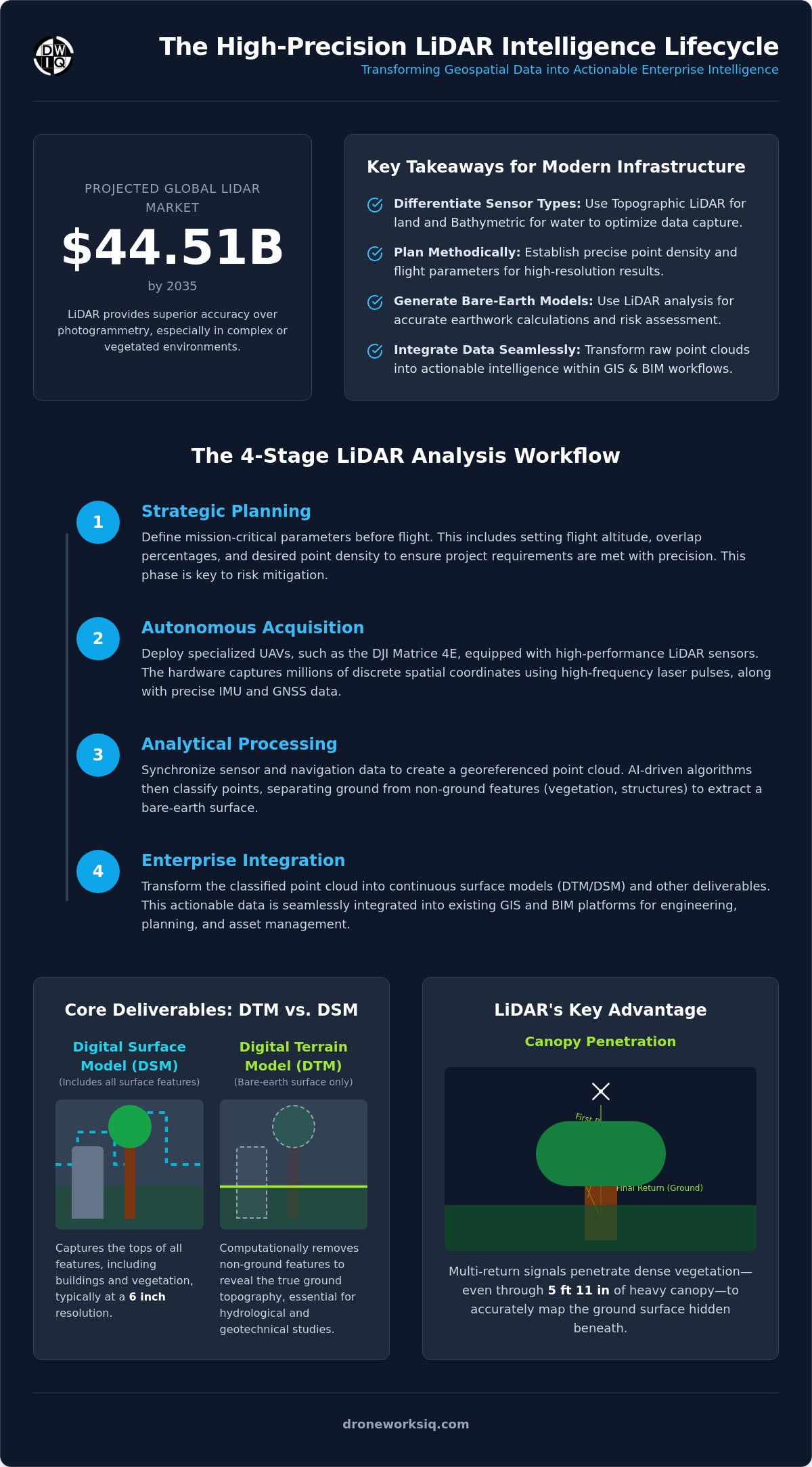
Content Flow: A linear four-stage progression: 1. Strategic Planning: Defining point density and flight parameters. 2. Autonomous Acquisition: High-resolution UAV data capture. 3. Analytical Processing: AI-driven bare-earth (DTM) extraction. 4. Enterprise Integration: Seamless delivery into GIS and BIM platforms.
Defining LiDAR Terrain Analysis for Enterprise Geospatial Intelligence
LiDAR (Light Detection and Ranging) functions as an active remote sensing technology that measures distance by illuminating targets with laser light and analyzing the reflected pulses. Understanding What is LiDAR is fundamental to grasping its role in modern geospatial intelligence. Unlike passive systems, LiDAR generates its own energy. It allows for high-precision data acquisition regardless of ambient lighting conditions. In enterprise-scale LiDAR terrain analysis, the distinction between topographic sensors, which use near-infrared lasers for land mapping, and bathymetric sensors, which employ green light to penetrate water bodies, is critical for mission success.
The precision of aerial datasets depends entirely on the integration of high-performance Inertial Measurement Units (IMU) and Global Navigation Satellite Systems (GNSS). These components work in tandem to record the sensor's exact orientation and position in three-dimensional space at the microsecond level. It's a technical necessity. Without this synchronized hardware stack, raw point clouds lack the georeferenced integrity required for industrial asset management or engineering-grade calculations.
The Core Deliverables: DTM vs. DSM
The primary outputs of LiDAR terrain analysis are categorized into two distinct models. A Digital Surface Model (DSM) captures the reflective surface of all features, including vegetation and man-made structures, typically at a 6 in resolution. Conversely, the Digital Terrain Model (DTM) represents the bare-earth surface by computationally stripping away non-ground features. The DTM is the essential baseline for hydrological modeling and geotechnical studies. It reveals the true topography hidden beneath surface obstructions that would otherwise obscure critical site data.
Canopy Penetration and Vegetation Filtering
LiDAR's unique capability lies in its multi-return signal processing. When a laser pulse encounters dense vegetation, portions of the beam pass through gaps in the foliage, even through 5 ft 11 in of heavy canopy cover, to reach the ground. The sensor records multiple returns for a single pulse. The first return typically represents the canopy top, while the final return identifies the ground surface. This mechanism allows for the generation of accurate elevation grids in areas where traditional photogrammetry fails. Ground-classified points are then isolated to produce high-resolution terrain models that reflect the actual soil surface with clinical accuracy.
Executing the LiDAR Terrain Analysis Workflow: A Strategic How-To
The transition from flight planning to actionable intelligence follows a rigid four-stage protocol. Precision is non-negotiable. Strategic mission planning initiates the process by defining flight parameters, such as overlap percentages and altitude, to achieve the specific point density required for the project's scale. During aerial data acquisition, specialized UAV hardware deploys a high-frequency remote sensing method to capture millions of discrete spatial coordinates across the project area.
The subsequent pre-processing phase is critical for data integrity. Engineers perform boresight alignment and trajectory optimization, synchronizing IMU and GNSS data to correct for sensor movement during flight. Once the point cloud is georeferenced, AI-driven classification algorithms separate ground points from vegetation and man-made structures. This automated filtering is where LiDAR terrain analysis achieves its superior accuracy, eliminating the human error and high costs associated with manual point classification. Organizations looking to optimize this phase should consider professional LiDAR data collection and analysis to ensure survey-grade results.
Advanced Point Cloud Rasterization
Rasterization transforms discrete point data into continuous surfaces. Technical teams utilize interpolation techniques like Kriging or Inverse Distance Weighting to generate elevation grids. These grids facilitate the creation of high-precision contour lines and hillshade maps, providing a clinical visualization of terrain relief. This step is essential for converting raw data into a format suitable for hydrological and geotechnical analysis.
AI-Enhanced Feature Extraction
Modern workflows leverage automation to identify specific infrastructure assets within the terrain model. By integrating AI-driven geospatial analytics, systems autonomously categorize utility poles, building footprints, and drainage patterns. This shift from manual digitization to algorithmic extraction significantly reduces the processing timeline for large-scale enterprise projects while maintaining high-fidelity results.
Strategic Applications in Site Selection and Infrastructure Management
The strategic deployment of LiDAR terrain analysis transforms site selection from a predictive exercise into a data-driven certainty. By providing a foundational layer of topographic intelligence, enterprise leaders can execute precise slope analysis and earthwork volume calculations before mobilizing heavy machinery. This proactive approach identifies geological hazards that traditional methods often overlook. It's a critical risk-reduction tool. Integrating these high-fidelity datasets directly enhances the infrastructure digital twin, ensuring that the virtual model reflects the physical asset's current environmental state with absolute precision.
For developers evaluating new parcels, pairing this high-resolution topographic data with the valuation resources available at BuyVacantLand.com ensures a comprehensive understanding of both the physical terrain and the investment value.
Temporal terrain comparisons serve as a sophisticated mechanism for erosion monitoring and coastal management. By capturing sequential datasets, organizations can quantify volumetric changes in soil and shoreline stability with clinical accuracy. This capability is essential for large-scale projects where environmental shifts directly impact structural integrity. Organizations requiring these high-precision insights should leverage specialized utility and pipeline inspection services to secure their critical corridors against environmental volatility.
Earthwork and Volumetric Analysis
Precision in volumetric calculations is a primary driver for cost control in large-scale construction. LiDAR systems achieve sub-6 inch vertical accuracy, allowing for the generation of highly reliable cut-and-fill models. This granularity reduces logistical overhead by preventing the over-ordering of materials or unexpected soil removal requirements. Accurate terrain data ensures that earthwork estimations remain within strict budgetary constraints, eliminating the financial volatility associated with inaccurate site surveys.
Utility Corridor and Pipeline Inspection
Managing utility corridors requires constant vigilance against environmental encroachment. LiDAR allows for the identification of vegetation threats and structural interference within right-of-way (ROW) areas with automated efficiency. For pipeline integrity management, mapping terrain stability is vital for predicting erosion-related failures. These insights facilitate a predictive maintenance framework that safeguards high-value infrastructure assets while minimizing the need for hazardous manual inspections.
Implementing LiDAR Intelligence: Integration and Strategic Consultation
Successful execution of LiDAR terrain analysis concludes with the seamless integration of processed datasets into established decision-making frameworks. Raw terrain data lacks utility until it's synthesized into actionable enterprise asset intelligence. This transition requires a methodical approach to data ingestion, ensuring that high-density point clouds translate into usable layers within Geographic Information Systems (GIS) and Building Information Modeling (BIM) environments. By embedding precise topographic data into these workflows, organizations create a persistent, accurate baseline for the entire infrastructure lifecycle.
Geospatial consulting serves as the final bridge between complex terrain metrics and strategic industrial application. Interpreting sub-6 inch vertical accuracy data requires specialized expertise to identify subtle geological indicators or structural risks. DroneWorksIQ provides the technical oversight necessary to transform these high-fidelity captures into strategic assets. Leveraging professional LiDAR data collection and analysis ensures that project-based datasets meet the rigorous standards required for large-scale enterprise oversight. It's about moving beyond simple mapping to achieve comprehensive oversight.
Infographic Direction: The LiDAR Terrain Workflow
Visual Concept: A four-step linear flow diagram illustrating the data lifecycle from acquisition to integration.
Design Aesthetic: Clean, minimalist layout with a white background and high-contrast black text. Use precise vector lines and clinical iconography to maintain an authoritative, high-tech feel.
Content Elements:
Step 1: Capture – Autonomous UAV aerial data acquisition focusing on high-resolution point density.
Step 2: Process – Boresight alignment and trajectory optimization for georeferenced integrity.
Step 3: Analyze – AI-driven classification and high-resolution DTM generation for bare-earth modeling.
Step 4: Integrate – Seamless delivery of actionable intelligence into existing GIS and BIM platforms.
Advancing Infrastructure Through High-Fidelity Terrain Intelligence
The transition from reactive site surveying to predictive geospatial intelligence is a technical necessity for modern enterprise operations. Advanced LiDAR terrain analysis provides the foundational accuracy required to move from raw point clouds to comprehensive digital twins, ensuring that every engineering decision is based on clinical data. By leveraging AI-driven classification and high-resolution modeling, organizations eliminate the structural ambiguities inherent in legacy surveying methods. This strategic shift not only optimizes capital expenditure but also fundamentally mitigates long-term operational risks across complex utility and construction corridors.
DroneWorksIQ offers national coverage for infrastructure intelligence, utilizing enterprise-grade AI-driven geospatial analytics to transform aerial imaging into strategic assets. Our specialized LiDAR data collection and analysis protocols are designed to handle high-stakes data environments with methodical accuracy. We provide specialized service fees tailored to specific project scales, ensuring efficient resource allocation for your organization. Consult with DroneWorksIQ for Advanced LiDAR Analysis to secure the precision your infrastructure demands. Achieve a new standard of geospatial oversight today.
Frequently Asked Questions
What is the standard accuracy for LiDAR terrain analysis in infrastructure projects?
Survey-grade LiDAR terrain analysis typically yields vertical accuracy within a range of 2 in to 4 in. Horizontal accuracy often exceeds 1 in to 2 in depending on the sensor's pulse rate and flight altitude. These sub-decimeter precision levels are mandatory for infrastructure projects requiring exact earthwork calculations and geotechnical modeling. Higher accuracies are achievable through rigorous boresight alignment and the strategic use of ground control points (GCPs) to anchor the coordinate system.
Can LiDAR terrain analysis penetrate dense forest canopy for bare-earth mapping?
LiDAR effectively penetrates dense vegetation by utilizing multi-return laser pulses. While the initial return might reflect from the top of a 5 ft 11 in canopy, subsequent pulses travel through foliage gaps to reach the soil surface. This capability allows for the generation of high-resolution bare-earth models (DTMs) in environments where traditional photogrammetry would only capture the vegetation surface. AI-driven classification then isolates these ground-classified points to produce a clean topographic grid for engineering analysis.
How does LiDAR terrain analysis differ from photogrammetry in site selection?
The primary distinction lies in the data acquisition mechanism. Photogrammetry is a passive remote sensing technique that relies on visible light and direct line-of-sight, making it ineffective in shadows or heavily wooded areas. LiDAR terrain analysis is an active system that generates its own light source, allowing it to penetrate vegetation and operate in varied lighting conditions. For site selection involving complex topography or dense cover, LiDAR provides the only reliable method for identifying the true ground surface and calculating precise slope gradients.
What software formats are standard for exporting LiDAR terrain deliverables?
Standard industry exports for raw point cloud data include LAS and compressed LAZ formats. For processed terrain models, GeoTIFF is the preferred raster format for DTMs and DSMs because it contains embedded georeferenced metadata. Vector-based deliverables, such as contour lines or site footprints, are typically provided in DXF, DWG, or Shapefile (SHP) formats to ensure seamless integration into CAD and GIS platforms. These formats facilitate immediate use within Building Information Modeling (BIM) environments for enterprise asset management.
How often should erosion monitoring via LiDAR be performed for coastal assets?
Coastal asset monitoring protocols generally dictate quarterly aerial surveys or immediate inspections following significant storm events. This frequency allows for precise temporal comparisons to quantify volumetric soil loss or shoreline recession with clinical accuracy. By establishing a high-resolution baseline, enterprise operators can identify erosion trends before they compromise structural integrity. Regular data collection ensures that risk-mitigation strategies are based on current terrain metrics rather than outdated projections.